|
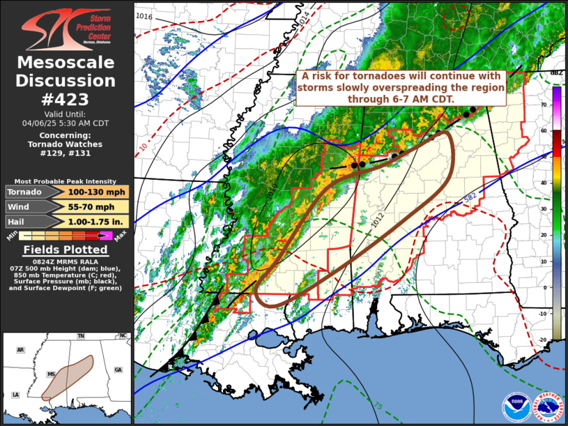
| Mesoscale Discussion 423 |
|
[an error occurred while processing this directive]
|
|
   Mesoscale Discussion 0423
   NWS Storm Prediction Center Norman OK
   0327 AM CDT Sun Apr 06 2025

   Areas affected...parts of sern MS into cntrl AL

   Concerning...Tornado Watch 129...131...

   Valid 060827Z - 061030Z

   The severe weather threat for Tornado Watch 129, 131 continues.

   SUMMARY...Circulations embedded within a line of pre-frontal storms,
   and perhaps additional more discrete storms near or just ahead of
   the line, will continue to pose a risk for brief tornadoes and/or
   locally damaging wind gusts while slowly spreading across
   southeastern Mississippi into central Alabama through 6-7 AM CDT.

   DISCUSSION...Convective development has largely remain focused along
   a slow moving to stalling outflow boundary, now near or south of a
   line from Chattanooga TN through Huntsville AL and Columbus MS,
   where it intersects outflow associated with a line of convection
   extending southward toward a slowly advancing cold front near and
   south-southwest of Jackson MS.  Near/east of this activity,
   inhibition associated with large-scale ridging aloft continues to
   suppress deep convective development; however one cell, emerging
   from pre-frontal bands of weak convection across southeastern
   Mississippi through the Alabama border vicinity, did recently
   intensify to the west of Meridian (and probably produce a tornado)
   prior to beginning to merge into the convective line.

   The large-scale mid/upper ridging and positively-tilted upstream
   troughing are very slowly progressing eastward, and it appears that
   ongoing thunderstorm activity will do likewise.  Although the Rapid
   Refresh suggests that a stronger southerly 850 mb jet core is in the
   process of shifting into the southern Appalachians, flow on the
   order of 40+ kt trails southwestward toward the Gulf coast.  This is
   maintaining sizable clockwise-curved low-level hodographs near weak
   pre-frontal surface troughing, where a narrow corridor of seasonably
   moist boundary layer air (including surface dew points near 70)
   appears to be supporting moderately large CAPE on the order of
   1000-2000 J/kg.

   ..Kerr.. 04/06/2025

   ...Please see www.spc.noaa.gov for graphic product...

   ATTN...WFO...BMX...MOB...JAN...LIX...

   LAT...LON   31069046 31648998 32698920 33088868 33338779 33668703
               33918634 33108633 32358731 31398882 30779003 31069046

   MOST PROBABLE PEAK TORNADO INTENSITY...100-130 MPH
   MOST PROBABLE PEAK WIND GUST...55-70 MPH
   MOST PROBABLE PEAK HAIL SIZE...1.00-1.75 IN
|
|
Top/All Mesoscale Discussions/Forecast Products/Home
|
|


 @NWSSPC