|
| Mesoscale Discussion 2187 |
|
< Previous MD Next MD >
|
|
Mesoscale Discussion 2187
NWS Storm Prediction Center Norman OK
0154 AM CST Sun Nov 03 2024
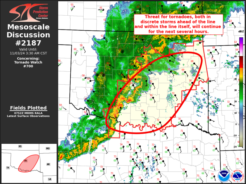
Areas affected...Central and Eastern OK
Concerning...Tornado Watch 700...
Valid 030754Z - 030930Z
The severe weather threat for Tornado Watch 700 continues.
SUMMARY...The threat for tornadoes, both within cells ahead of the
convective line and within the convective line itself, will persist
for at least the next few hours. Tornado Watch 700 was recently
issued across central and eastern Oklahoma to address this threat.
DISCUSSION...Several discrete supercells have matured within the
open warm sector across central OK. This includes the supercell over
Stephens County, which had a rotational velocity over 65 kt for
several scans within the last 25 minutes. The maturing of these
cells corresponded with the strengthening of the surface winds by 5
to 10 kt within the warm sector, with southeasterly winds now
gusting 20 to 25 kt. The longevity of these discrete cells will be
limited by the approaching convective line, but the persistence of
strong low-level flow suggests the tornado threat will likely
persist within the line itself as it continues eastward. Given this
continued threat for tornadoes in both discrete cells ahead of the
line and QLCS circulations within the line, a Tornado Watch was
recently issued for central and eastern OK. The airmass ahead of the
line is expected to remain at least modestly unstable into eastern
OK, justifying its inclusion in the recent watch.
..Mosier.. 11/03/2024
...Please see www.spc.noaa.gov for graphic product...
ATTN...WFO...TSA...FWD...OUN...
LAT...LON 34999799 36139632 36049467 33859627 33829841 34999799
|
|
Top/All Mesoscale Discussions/Forecast Products/Home
|
|


 @NWSSPC