|
| Mesoscale Discussion 2153 |
|
< Previous MD Next MD >
|
|
Mesoscale Discussion 2153
NWS Storm Prediction Center Norman OK
0823 PM CDT Sun Oct 20 2024
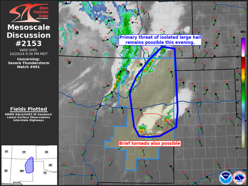
Areas affected...Eastern NM
Concerning...Severe Thunderstorm Watch 691...
Valid 210123Z - 210330Z
The severe weather threat for Severe Thunderstorm Watch 691
continues.
SUMMARY...An isolated large hail should persist for the next few
hours across east-central to northeast New Mexico, with a brief
tornado also possible in east-central New Mexico.
DISCUSSION...Two primary corridors of thunderstorms are ongoing; one
east of the Sangre de Cristo Mountains near the Raton Mesa, and the
other south of the I-40 corridor in east-central NM. The northern
storms should pose a continued threat of small to marginally severe
hail of 0.75 to 1.25 inches, based on prior MRMS MESH signatures and
presence of weak surface-based buoyancy plume. The discrete cells
farther south have recently consolidated to two storms and these may
gradually intensify over the next hour or so within a favorable
supercell wind profile. FDX VWP data confirms an enlarged 0-1 km
hodograph, beneath by strong southwesterly speed shear above 3 km.
This could result in a sustained supercell being capable of a brief
tornado, along with large hail from quarter to golf ball size
through about 03-04Z. Thereafter, additional storms will probably
increase in between the two separate regimes as low-level warm
theta-e advection becomes maximized and a cluster mode dominates,
while the boundary layer further cools.
..Grams.. 10/21/2024
...Please see www.spc.noaa.gov for graphic product...
ATTN...WFO...LUB...AMA...PUB...ABQ...
LAT...LON 37450359 37370295 34890284 34230293 33880371 33830426
33870470 34250495 35620520 36260486 36990419 37450359
|
|
Top/All Mesoscale Discussions/Forecast Products/Home
|
|


 @NWSSPC