|
| Mesoscale Discussion 2136 |
|
< Previous MD Next MD >
|
|
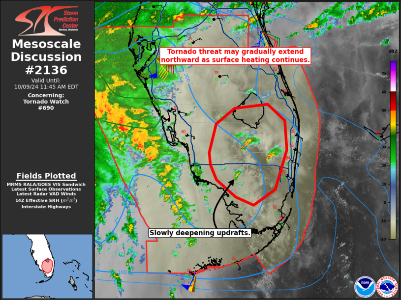
   Mesoscale Discussion 2136
   NWS Storm Prediction Center Norman OK
   0919 AM CDT Wed Oct 09 2024

   Areas affected...Portions of South Florida

   Concerning...Tornado Watch 690...

   Valid 091419Z - 091545Z

   The severe weather threat for Tornado Watch 690 continues.

   SUMMARY...Potential for tornadoes will continue late this morning
   into the afternoon. The threat will gradually expand northward as
   heating destabilizes the boundary layer. Wind fields will also
   increasingly support tornadoes with time.

   DISCUSSION...Low-level rotation has been increasing in two supercell
   storms south of Lake Okeechobee. One storm produced a tornado in
   Collier County just before moving into Hendry County. More recently,
   the storm in central Broward County produced a tornado as well.
   Storms earlier this morning generally began to weaken near Lake
   Okeechobee, but temperatures have been increasing with surface
   heating. That being said, the tornado threat will likely begin to
   extend farther north over the next few hours. Additional updrafts in
   eastern Collier County have also been slowly deepening over the last
   hour. This activity could intensify and similarly be capable of
   producing a tornado. Potential for tornadoes, including a strong
   tornado, should continue to increase as stronger low-level flow
   across the peninsula expands as Milton moves eastward and its wind
   field concurrently expands.

   ..Wendt.. 10/09/2024

   ...Please see www.spc.noaa.gov for graphic product...

   ATTN...WFO...MFL...MLB...

   LAT...LON   25688107 25938137 26148148 26338149 26748138 26978108
               27048055 26808027 26368023 25788043 25558078 25688107
|
|
Top/All Mesoscale Discussions/Forecast Products/Home
|
|


 @NWSSPC