|
| Mesoscale Discussion 2104 |
|
< Previous MD Next MD >
|
|
Mesoscale Discussion 2104
NWS Storm Prediction Center Norman OK
0355 PM CDT Tue Sep 24 2024
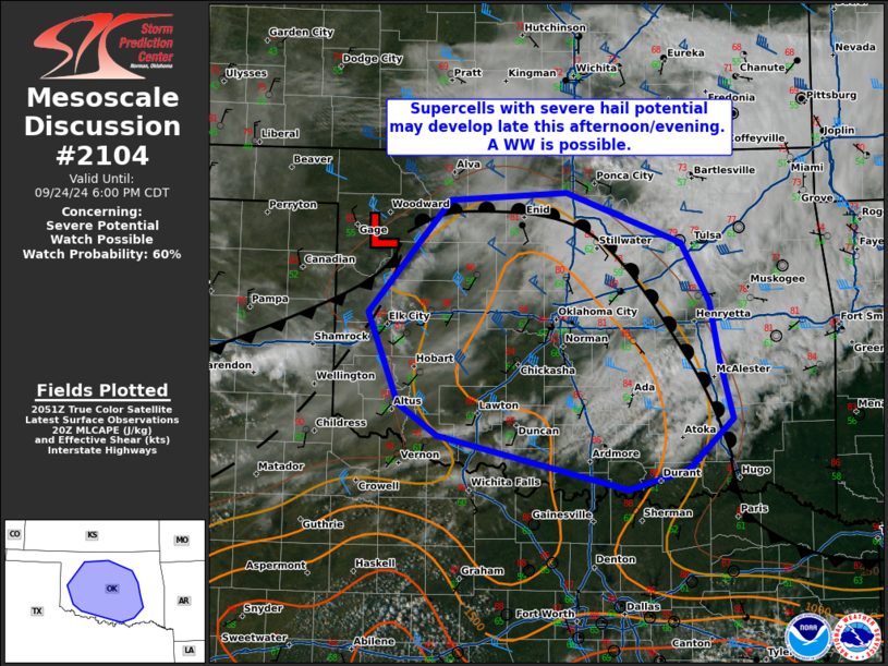
Areas affected...central Oklahoma
Concerning...Severe potential...Watch possible
Valid 242055Z - 242300Z
Probability of Watch Issuance...60 percent
SUMMARY...Thunderstorms are expected to develop along a cold front
across west-central OK late this afternoon into this evening. Strong
mid-level flow, adequate surface moisture and buoyancy will support
a risk for severe hail and isolated damaging winds. Confidence in
the convective evolution is somewhat low, but the severe risk may
require a weather watch.
DISCUSSION...Afternoon WV imagery showed a large upper trough over
the central US. Behind the large trough, an embedded shortwave
perturbation was moving out of the central Rockies and over the
southern Plains. beneath the mid-level ascent ahead of the shortwave
trough, a weak surface low and cold front were moving into western
OK. Visible imagery and SPC mesoanalysis show towering cumulus has
begun deepening near the triple point and along the trailing front
into the TX Panhandle. Low to mid 60s F surface dewpoints and 7-7.5
C/km mid-level lapse rates were supporting weak to moderate
destabilization despite lingering cirrostratus across OK.
Further heating and weak low-level warm advection ahead of the
surface low should support continued destabilization and removal of
remaining inhibition through the afternoon. Scattered thunderstorm
development is expected along the cold front, and more elevated
development near/north of the warm front with storms moving
east/southeast towards central OK. Increasingly strong mid and
upper-level flow from the KTLX/KVNX VADs are supporting long
hodographs favorable for supercells. While lapse rates and buoyancy
are not overly impressive, modestly cool mid-level temps, robust
forcing and strong deep-layer shear suggest any supercells that
develop will be capable of severe hail and isolated damaging gusts.
Confidence in the exact timing of storm development and the
convective evolution remains unclear. Most hi-res guidance favors
near-surface based storms developing late this afternoon, with some
solutions holding off until early evening. While uncertain, the
environment is expected to support a risk for severe hail, and a
watch may be needed.
..Lyons/Guyer.. 09/24/2024
...Please see www.spc.noaa.gov for graphic product...
ATTN...WFO...TSA...FWD...OUN...
LAT...LON 34549557 34099608 33909673 34049729 34399884 34689928
35529963 36549872 36629741 36159613 35629583 35109573
34549557
|
|
Top/All Mesoscale Discussions/Forecast Products/Home
|
|


 @NWSSPC