|
| Mesoscale Discussion 2077 |
|
< Previous MD Next MD >
|
|
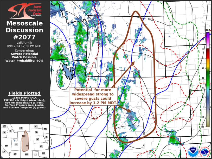
   Mesoscale Discussion 2077
   NWS Storm Prediction Center Norman OK
   1133 AM CDT Tue Sep 17 2024

   Areas affected...western and central Colorado....central into
   eastern Wyoming

   Concerning...Severe potential...Watch possible

   Valid 171633Z - 171830Z

   Probability of Watch Issuance...40 percent

   SUMMARY...A gradual increase in thunderstorm development appears
   likely to continue through Noon-2 PM MDT.  While stronger storms
   posing a risk for locally severe wind gusts probably will remain
   widely scattered in the near term, it is possible this could become
   more widespread across and east of the Continental Divide this
   afternoon.

   DISCUSSION...Downstream of a vigorous short wave trough, now in the
   process of pivoting northeastward across the Great Basin, scattered
   thunderstorm development is underway in the presence of weak to
   modest destabilization.  Low-level lapse rates are still in the
   process of steepening in response to boundary-layer heating and
   mixing, beneath the leading edge of mid-level cooling.  However,
   downward mixing of 40-50+ kt ambient deep-layer mean flow is already
   contributing to severe gusts in the widely scattered stronger
   storms.  This is likely to continue through the next few hours, as
   the mid/upper trough approaches the Wyoming/Colorado Rockies and
   boundary-layer destabilization progresses.

   Although the extent of the severe weather potential into and across
   the Continental Divide through 18-20Z remains a bit unclear, the
   gradual upscale growth of a consolidating line of storms appears at
   least possible along/ahead of the leading edge of the mid-level
   cooling.  This may be accompanied by a strengthening surface cold
   pool accompanied by potential for increasingly widespread strong to
   severe wind gusts.

   ..Kerr/Gleason.. 09/17/2024

   ...Please see www.spc.noaa.gov for graphic product...

   ATTN...WFO...UNR...PUB...BOU...CYS...ABQ...BYZ...RIW...GJT...

   LAT...LON   45310677 44470587 43470512 40750502 38910497 37430523
               36670750 37550837 39730847 40750851 42420854 43510758
               45310677
|
|
Top/All Mesoscale Discussions/Forecast Products/Home
|
|


 @NWSSPC