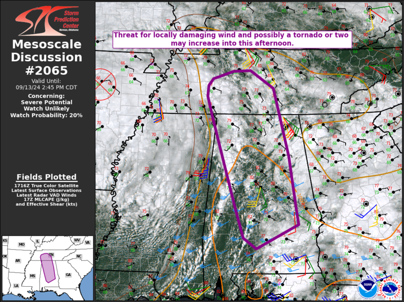
   Mesoscale Discussion 2065
   NWS Storm Prediction Center Norman OK
   1221 PM CDT Fri Sep 13 2024

   Areas affected...Parts of AL into middle TN

   Concerning...Severe potential...Watch unlikely

   Valid 131721Z - 131945Z

   Probability of Watch Issuance...20 percent

   SUMMARY...The threat for locally damaging wind and possibly a
   tornado may increase into this afternoon.

   DISCUSSION...A remnant surface low is located over northern AR early
   this afternoon. An occluded front extends east-northeast of the low
   into western TN, then extends southeast as a stationary or warm
   front across parts of northern/central AL into western GA. Farther
   south, a cold front is moving across MS, with a surface trough/wind
   shift noted to the east from western AL into southern MS.

   In the vicinity of these boundaries, convection is gradually
   increasing from western AL into southern middle TN, and a few cells
   across northwest AL have exhibited some weak rotation. While
   low-level flow/shear has gradually decreased as the remnant of
   Tropical Cyclone Francine has weakened, effective SRH of around 100
   m2/s2 and modestly favorable deep-layer shear will continue to favor
   occasionally organized convection into this afternoon. MLCAPE will
   increase to near or above 1000 J/kg, with an increase in convective
   coverage expected with time within a weakly capped environment.

   A few marginal supercells could evolve with time, and a tornado
   cannot be ruled out, especially in a zone between the surface
   trough/wind shift approaching from the west and the effective warm
   front to the east, where low-level flow will remain locally backed
   as gradual heating/destabilization continues. Otherwise, locally
   damaging winds will be possible, especially if any localized
   clustering of convection can develop with time.

   ..Dean/Gleason.. 09/13/2024

   ...Please see www.spc.noaa.gov for graphic product...

   ATTN...WFO...OHX...BMX...HUN...MOB...MEG...

   LAT...LON   32228565 31618689 31888728 32568749 34138797 34948822
               35448837 35718835 35898821 36088759 36108707 35658637
               33948592 32638572 32228565
|


 @NWSSPC