Mesoscale Discussion 2047
NWS Storm Prediction Center Norman OK
0106 PM CDT Wed Sep 04 2024
Areas affected...portions of southern WY...northwestern
CO...northeastern UT...and far western NE
Concerning...Severe potential...Watch unlikely
Valid 041806Z - 042000Z
Probability of Watch Issuance...20 percent
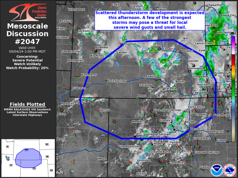
SUMMARY...Scattered thunderstorm development is expected this
afternoon across southern WY, northern CO, and portions of
northeastern UT and far western NE. The strongest storms may pose a
threat for local severe wind gusts and small hail.
DISCUSSION...Deeper updraft development is underway across the
region, predominantly in advance of a mid-level wave progressing
eastward through the region. Associated upper-level ventilation is
supporting storm maturation across southeastern WY. Convective
development is also occurring in northeastern UT, aided by enhanced
westerlies aloft and diurnal heating amidst the Uinta Mountains.
Continued updraft intensification is expected through the afternoon
as the wave propagates eastward through the area and diurnal heating
continues to ramp up.
Surface conditions are relatively cool across the area in the wake
of a cold frontal passage. As such, MLCAPE values are relatively low
(around 250-500 J/kg) and some convective inhibition remains.
However, diurnal heating will support continued updraft development
across the area. Updrafts will be relatively high-based, but steep
mid-level lapse rates -- owing to synoptic-scale ascent ahead of the
mid-level wave -- could yield MLCAPE around 500-1000 J/kg in some
areas. Lengthening, relatively straight hodographs, characterized by
bulk shear around 30-40 kts, could support a few more persistent,
supercellular structures. Some severe wind gusts and small hail will
be the primary threat with these storms through the afternoon. The
threat is expected to remain rather localized in nature, and watch
issuance is not anticipated at this time.
..Flournoy/Squitieri/Mosier.. 09/04/2024
...Please see www.spc.noaa.gov for graphic product...
ATTN...WFO...BOU...CYS...RIW...GJT...SLC...
LAT...LON 40041022 40911053 42051009 43190817 43250573 42610421
41640359 40310366 39440567 39450839 40041022
|


 @NWSSPC