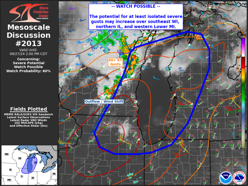
   Mesoscale Discussion 2013
   NWS Storm Prediction Center Norman OK
   1125 AM CDT Tue Aug 27 2024

   Areas affected...southeast Wisconsin...northern Illinois...western
   Lower Michigan

   Concerning...Severe potential...Watch possible

   Valid 271625Z - 271900Z

   Probability of Watch Issuance...60 percent

   SUMMARY...Storms may continue to increase in coverage and intensity
   along a weak boundary, from eastern WI into northern IL. Scattered
   strong to severe gusts will be possible.

   DISCUSSION...Storms which formed in a semi-elevated regime over
   central WI have continued to expand north-south in coverage, with
   recently reported gusts just below severe limits (40-50 kt range).
   Addition convection is now forming southward along a subtle wind
   shift into southern WI, and additional storms are anticipated into
   northern IL.

   The air mass is quite moist and unstable over the entire area, and
   low-level lapse rates will continue to steepen over the next several
   hours. Although shear is weak, the ample precipitable water, MUCAPE,
   and existing forcing mechanisms (outflow boundary and wind shift to
   the southwest) suggest additional strong to severe gusts will
   develop later this afternoon.

   While convection near Green Bay will soon move offshore, westerly
   925/850 mb winds may maintain an unstable feed of air above the
   cooler lake surface. If storms can maintain composure over Lake MI,
   the heated air over western Lower MI may then support severe gusts.

   Farther south into northern IL and extending into southwest Lower
   MI, the severe risk will is conditional on enough convection forming
   along the weak boundary. Given a very moist air mass with mid to
   upper 70s F dewpoints, and current satellite trends, the thinking is
   that this may indeed be the case, and trends will be closely
   monitored. A severe thunderstorm watch may be needed over parts of
   the region this afternoon.

   ..Jewell/Guyer.. 08/27/2024

   ...Please see www.spc.noaa.gov for graphic product...

   ATTN...WFO...APX...IWX...GRR...GRB...LOT...MKX...DVN...

   LAT...LON   43208515 42298568 41618640 41358725 41308782 41318876
               41508937 41958963 42568925 43128882 43898837 44458817
               44638796 45138567 45038503 44558471 43978474 43208515
|


 @NWSSPC