|
| Mesoscale Discussion 1999 |
|
< Previous MD Next MD >
|
|
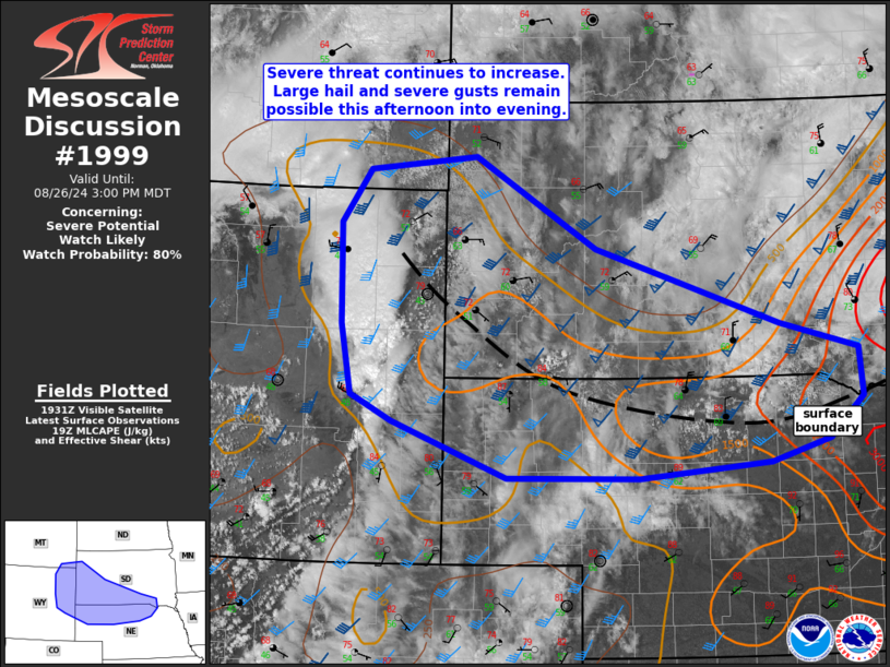
   Mesoscale Discussion 1999
   NWS Storm Prediction Center Norman OK
   0237 PM CDT Mon Aug 26 2024

   Areas affected...northeast WY into western/southern SD and northern
   NE

   Concerning...Severe potential...Watch likely

   Valid 261937Z - 262100Z

   Probability of Watch Issuance...80 percent

   SUMMARY...Thunderstorms are expected to increase in coverage and
   intensity through the afternoon. Damaging wind gusts and large to
   very large hail remain possible. A watch will likely be needed soon.

   DISCUSSION...Thunderstorms over eastern WY have slowly increased in
   intensity the past hour or so as this activity shifts east into
   somewhat better instability. Additional deepening of cumulus has
   been noted in visible satellite imagery along the outflow reinforced
   frontal draped near the SD/NE border. Pockets of stronger heating
   and cooling aloft has allowed MLCAPE to increase to around 1000
   J/kg. Somewhat stronger instability is noted with eastward extent
   along the surface boundary across north-central NE, and towering
   cumulus have recently developed in this area. While convective
   evolution remains a bit uncertain, modified 18z RAOB from UNR, along
   with forecast soundings across the region, continue to indicate a
   risk for large to very large hail and severe gusts. A watch will
   likely be needed for portions of the MCD area soon.

   ..Leitman/Guyer.. 08/26/2024

   ...Please see www.spc.noaa.gov for graphic product...

   ATTN...WFO...FSD...OAX...ABR...LBF...UNR...CYS...BYZ...

   LAT...LON   42800541 43550556 44640559 45210517 45350360 44380184
               43569915 43279800 42769795 42319845 42089931 41910121
               41930313 42520481 42800541
|
|
Top/All Mesoscale Discussions/Forecast Products/Home
|
|


 @NWSSPC