|
| Mesoscale Discussion 1961 |
|
< Previous MD Next MD >
|
|
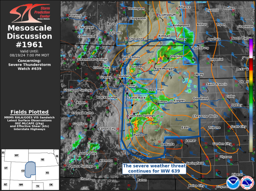
   Mesoscale Discussion 1961
   NWS Storm Prediction Center Norman OK
   0707 PM CDT Mon Aug 19 2024

   Areas affected...Eastern Colorado

   Concerning...Severe Thunderstorm Watch 639...

   Valid 200007Z - 200100Z

   The severe weather threat for Severe Thunderstorm Watch 639
   continues.

   SUMMARY...Storms capable of damaging winds and hail are ongoing
   across the WW 639, and are expected to persist into the early
   evening hours.

   DISCUSSION...A few ongoing convective clusters will continue to be
   capable of damaging winds and hail, supported by MLCAPE > 2000 J/kg
   and 45-50 kts of deep-layer vertical shear. Recent radar over
   east-central and southeastern Colorado shows outflow surging ahead
   of the convection, and the greatest threat for any damaging winds
   will be with any upscale growth that occurs on the leading edge of
   this outflow. In northern Colorado, a more isolated supercell
   thunderstorm is ongoing, with southeasterly flow and temperatures in
   the mid-to-upper 70s F out ahead of it. This should support at least
   some maintenance of a severe threat into the evening hours.
   Convective coverage and intensity should diminish as the nocturnal
   boundary layer stabilizes, with watch expiration set for 03Z.

   ..Halbert/Squitieri.. 08/20/2024

   ...Please see www.spc.noaa.gov for graphic product...

   ATTN...WFO...LBF...GLD...PUB...BOU...CYS...

   LAT...LON   40600210 40460208 38280205 38210268 38220301 38220334
               38090342 37860336 37710343 37640359 37610403 37710460
               37900485 38170503 38620500 38990499 39500498 39950492
               40350492 40700465 40970425 41130393 41180311 41010244
               40600210
|
|
Top/All Mesoscale Discussions/Forecast Products/Home
|
|


 @NWSSPC