|
| Mesoscale Discussion 1959 |
|
< Previous MD Next MD >
|

|
   Mesoscale Discussion 1959
   NWS Storm Prediction Center Norman OK
   0321 PM CDT Mon Aug 19 2024

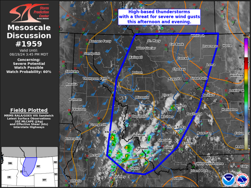
   Areas affected...much of western Montana and the central Idaho
   Mountains

   Concerning...Severe potential...Watch possible

   Valid 192021Z - 192145Z

   Probability of Watch Issuance...60 percent

   SUMMARY...High-based thunderstorms are likely this afternoon and
   evening with a threat for severe wind gusts.

   DISCUSSION...Temperatures have warmed into the mid 80s across the
   central Idaho mountains which has eroded inhibition and resulted in
   scattered thunderstorm development. RAP forecast soundings show very
   deep mixing (perhaps as deep as 5-6km) which will support
   evaporative cooling and strengthening downbursts. The downstream
   environment across western Montana still shows moderate inhibition
   (per SPC mesoanalysis) which should erode further as warming
   continues. As this occurs, expect strengthening of ongoing storms
   and additional development across western Montana. Moderate
   upper-level flow ahead of the Pacific Northwest upper-level trough
   will overspread this region late this afternoon and evening which
   may result in storm organization and a greater severe weather
   threat. A severe thunderstorm watch may be needed.

   ..Bentley/Hart.. 08/19/2024

   ...Please see www.spc.noaa.gov for graphic product...

   ATTN...WFO...TFX...PIH...MSO...BOI...OTX...

   LAT...LON   44431433 44981525 47541489 49021400 49041176 49030985
               48580993 46571090 45291195 44541301 44371348 44431433
|
|
Top/All Mesoscale Discussions/Forecast Products/Home
|
|


