|
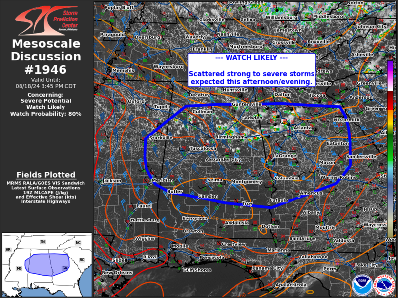
| Mesoscale Discussion 1946 |
|
< Previous MD Next MD >
|
|
   Mesoscale Discussion 1946
   NWS Storm Prediction Center Norman OK
   0221 PM CDT Sun Aug 18 2024

   Areas affected...northern Alabama...northern Georgia

   Concerning...Severe potential...Watch likely

   Valid 181921Z - 182045Z

   Probability of Watch Issuance...80 percent

   SUMMARY...Scattered strong to severe thunderstorms to increase in
   coverage through the afternoon with potential for large hail and
   damaging wind.

   DISCUSSION...Visible satellite trends show deepening cu across much
   of northern Alabama and Georgia, with a few cells developing over
   the last 30 min to an hour. Thunderstorm development is likely to
   expand southward in coverage across these regions over the next 1-2
   hours as a cold front sags south through time. The air mass ahead of
   the front is characterized by MLCAPE around 1000-2000 J/kg with
   temperatures in the upper 80s - mid 90s and dew points in the low to
   mid 70s. A belt of deep layer shear around 35-40 kts and the moist
   and unstable air mass will support multicell clusters, capable of
   downbursts and instances of severe hail. A watch will likely be
   needed to cover this threat soon.

   ..Thornton/Hart.. 08/18/2024

   ...Please see www.spc.noaa.gov for graphic product...

   ATTN...WFO...GSP...FFC...TAE...BMX...HUN...MOB...MEG...JAN...

   LAT...LON   33528891 34388768 34448666 34448588 34468471 34398380
               34358292 34118275 33778266 33458263 33078264 32868264
               32818267 32378308 31788505 31908645 32088756 32148810
               32348855 32528870 32738883 33018890 33438890 33528891
|
|
Top/All Mesoscale Discussions/Forecast Products/Home
|
|


 @NWSSPC