|
| Mesoscale Discussion 1932 |
|
< Previous MD Next MD >
|
|
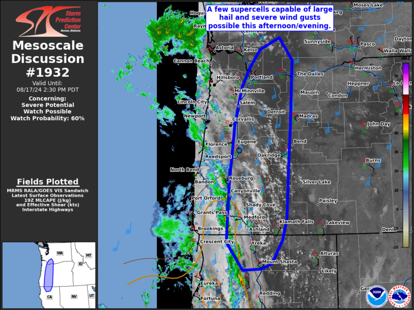
   Mesoscale Discussion 1932
   NWS Storm Prediction Center Norman OK
   0236 PM CDT Sat Aug 17 2024

   Areas affected...far northern California...along the Oregon Cascades
   and into the far southern Washington Cascades.

   Concerning...Severe potential...Watch possible

   Valid 171936Z - 172130Z

   Probability of Watch Issuance...60 percent

   SUMMARY...A few supercells capable of large hail and severe wind
   gusts are possible this afternoon and evening from northern
   California to the south Washington Cascades.

   DISCUSSION...Weak instability has started to develop across northern
   California and into southern Washington ahead of a strong mid-level
   trough. Expect instability to increase through the afternoon as
   surface heating continues, low-level moisture advects northward, and
   temperatures cool aloft. Ascent associated with the strong
   negatively tilted shortwave trough currently approaching the
   northern California coast has started to overspread northern
   California and southern Oregon where an increase in lightning
   activity is evident. In addition, some mini supercell structures are
   evident which is not surprising given the strong flow aloft (45
   knots at 500mb and nearly 100 knots above 300mb per MFR and SLE 18Z
   RAOBs). Continued surface heating and steepening lapse rates/cooling
   aloft should lead to a thermodynamic profile supporting more robust
   storm/supercell development and the potential for some large hail.
   While stronger storms will be favored over the higher terrain of the
   Cascades, storm motion may bring some of these storms into the
   foothills or perhaps even the Willamette Valley later this
   afternoon/evening.

   A severe thunderstorm watch may be needed to address this threat.

   ..Bentley/Hart.. 08/17/2024

   ...Please see www.spc.noaa.gov for graphic product...

   ATTN...WFO...PDT...MFR...SEW...PQR...EKA...

   LAT...LON   41832336 43132329 44532313 45362292 45792268 46232233
               46492171 45992130 44562136 43432145 42372151 41862164
               41342198 41222231 41192287 41832336
|
|
Top/All Mesoscale Discussions/Forecast Products/Home
|
|


 @NWSSPC