|
| Mesoscale Discussion 1919 |
|
< Previous MD Next MD >
|

|
   Mesoscale Discussion 1919
   NWS Storm Prediction Center Norman OK
   1040 AM CDT Fri Aug 16 2024

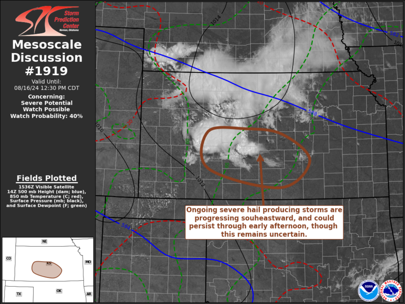
   Areas affected...parts of central/southern Kansas

   Concerning...Severe potential...Watch possible

   Valid 161540Z - 161730Z

   CORRECTED FOR TYPO

   Probability of Watch Issuance...40 percent

   SUMMARY...It remains unclear how much longer ongoing scattered
   severe hail producing storms will persist.  But trends are being
   monitored, and it is possible that a severe weather watch may become
   necessary.

   DISCUSSION...Elevated moisture return within forcing for ascent
   associated with lower/mid-tropospheric warm advection has been
   sufficient to overcome mid-level inhibition and support the
   initiation of scattered vigorous thunderstorm development.  CAPE for
   lifted parcels, in the presence of steep lapse rates, may be in
   excess of 2000 J/kg.  More certain, shear beneath 30-40+
   west-northwesterly mid/upper flow is strong and more than sufficient
   for supercells capable of producing severe hail.

   Based on model output, it remains unclear how much longer this will
   continue.  However, through early afternoon, the forcing for ascent
   is forecast to generally continue spreading east-southeastward
   through south central Kansas near/north of Medicine Lodge and
   Wichita, where a warmer and more moist boundary-layer may
   destabilize sufficiently to support notable further intensification.

   ..Kerr/Thompson.. 08/16/2024

   ...Please see www.spc.noaa.gov for graphic product...

   ATTN...WFO...ICT...DDC...

   LAT...LON   38609999 38679887 38549776 37929693 37279783 37739997
               38609999
|
|
Top/All Mesoscale Discussions/Forecast Products/Home
|
|


