|
| Mesoscale Discussion 1913 |
|
< Previous MD Next MD >
|

|
   Mesoscale Discussion 1913
   NWS Storm Prediction Center Norman OK
   0746 PM CDT Thu Aug 15 2024

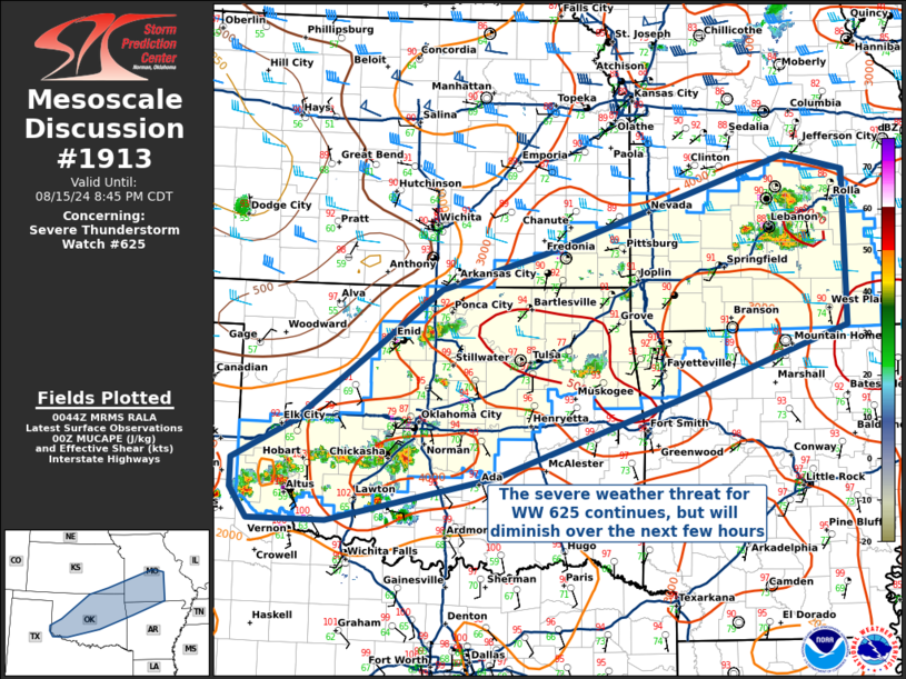
   Areas affected...Oklahoma...southern Missouri...far southeastern
   Kansas...and far northwestern Arkansas

   Concerning...Severe Thunderstorm Watch 625...

   Valid 160046Z - 160145Z

   The severe weather threat for Severe Thunderstorm Watch 625
   continues.

   SUMMARY...The threat for WW 625 continues, but should gradually
   diminish as the nocturnal boundary layer stabilizes.

   DISCUSSION...Multiple loosely organized clusters of thunderstorms
   are ongoing across WW 625, and strong buoyancy coupled with PWAT
   values near 2.00 inches will continue to support a threat for
   damaging winds and some hail. However, this threat should gradually
   diminish after dark in the presence of a stabilizing nocturnal
   boundary layer and absence of large-scale forcing.

   ..Halbert/Squitieri.. 08/16/2024

   ...Please see www.spc.noaa.gov for graphic product...

   ATTN...WFO...LSX...LZK...SGF...TSA...ICT...OUN...LUB...AMA...

   LAT...LON   34849646 34339878 34339986 34680009 35010009 35439925
               36329809 36969724 37369582 38359279 38459243 38289160
               36539160 35729393 34849646
|
|
Top/All Mesoscale Discussions/Forecast Products/Home
|
|


