|
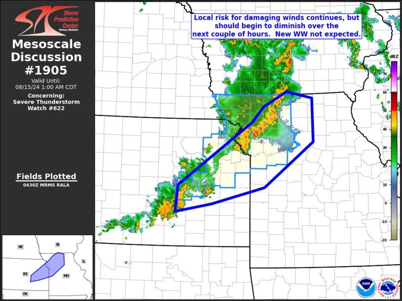
| Mesoscale Discussion 1905 |
|
< Previous MD Next MD >
|

|
   Mesoscale Discussion 1905
   NWS Storm Prediction Center Norman OK
   1132 PM CDT Wed Aug 14 2024

   Areas affected...parts of eastern Kansas into west-central and
   northwestern Missouri

   Concerning...Severe Thunderstorm Watch 622...

   Valid 150432Z - 150600Z

   The severe weather threat for Severe Thunderstorm Watch 622
   continues.

   SUMMARY...Local risk for damaging wind gusts continues from
   northwestern Missouri into eastern Kansas.  Risk should begin to
   gradually diminish in the next 1 to 2 hours.

   DISCUSSION...Latest radar loop shows a fairly well-developed line of
   storms -- with some embedded bowing -- moving eastward across
   northwestern Missouri and northeastern Kansas.  Less-organized
   convection -- where local risk for gusty winds is ongoing -- extends
   southwestward to near the ICT (Wichita, KS) area.

   The greatest short-term threat is expected in/around the Kansas City
   metro area, where the most unstable airmass (around 2500 J/kg
   mixed-layer CAPE per RAP-based objective analysis) is indicated.
   Here, local gusts in excess of 60 to 65 MPH will be possible in the
   next hour or so.

   With time, the cooling/stabilizing boundary layer along with lesser
   instability with eastward extent suggests that storms will begin to
   gradually diminish in intensity, and thus severe potential.  As
   such, the current 15/06Z expiration of WW 622 seems appropriate,
   though a local extension in time could be implemented for a few
   counties south/east of the existing watch if trends warrant.

   ..Goss.. 08/15/2024

   ...Please see www.spc.noaa.gov for graphic product...

   ATTN...WFO...DMX...EAX...TOP...ICT...

   LAT...LON   37999576 37809684 38449677 39939454 40309418 40659348
               40499272 39469270 38389418 37999576
|
|
Top/All Mesoscale Discussions/Forecast Products/Home
|
|


