|
| Mesoscale Discussion 1898 |
|
< Previous MD Next MD >
|

|
   Mesoscale Discussion 1898
   NWS Storm Prediction Center Norman OK
   0105 AM CDT Wed Aug 14 2024

   Areas affected...south-central into southeast NE

   Concerning...Severe Thunderstorm Watch 621...

   Valid 140605Z - 140700Z

   The severe weather threat for Severe Thunderstorm Watch 621
   continues.

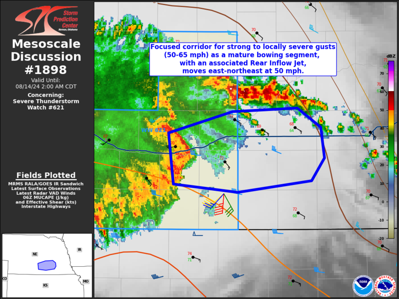
   SUMMARY...A focused corridor for strong to locally severe gusts
   (50-65 mph) will extend through the eastern part of Severe
   Thunderstorm Watch #621 and perhaps a few counties farther east.  A
   local watch extension-in-area could be utilized if observational
   trends warrant.

   DISCUSSION...Radar imagery shows a mature bowing segment with an
   implied Rear Inflow Jet moving quickly east across southern NE at 50
   mph.  Strong low-level warm-air advection indicative in the KUEX VAD
   data (45 kt southerly flow at 1.5 km AGL) will continue to sustain a
   background environment favorable for a continuation of the bowing
   segment into eastern portions of NE through the early overnight.
   Surface analysis shows temperatures ranging from the upper 60s to
   lower 70s with mid to upper 60s dewpoints ahead of the squall line.
   Appreciable convective inhibition and a gradual lessening of
   buoyancy (per objective analysis data and 00 UTC area raob data)
   will likely limit and constrict the corridor for strong to severe
   gusts to the apex of the bow and immediate adjacent areas before
   this potential diminishes in eastern NE.

   ..Smith.. 08/14/2024

   ...Please see www.spc.noaa.gov for graphic product...

   ATTN...WFO...OAX...GID...

   LAT...LON   40849907 41049833 41079758 40899731 40639727 40429742
               40329828 40409902 40849907
|
|
Top/All Mesoscale Discussions/Forecast Products/Home
|
|


