|
| Mesoscale Discussion 1891 |
|
< Previous MD Next MD >
|

|
   Mesoscale Discussion 1891
   NWS Storm Prediction Center Norman OK
   1253 PM CDT Tue Aug 13 2024

   Areas affected...parts of southern South Carolina

   Concerning...Severe potential...Watch unlikely

   Valid 131753Z - 132030Z

   Probability of Watch Issuance...20 percent

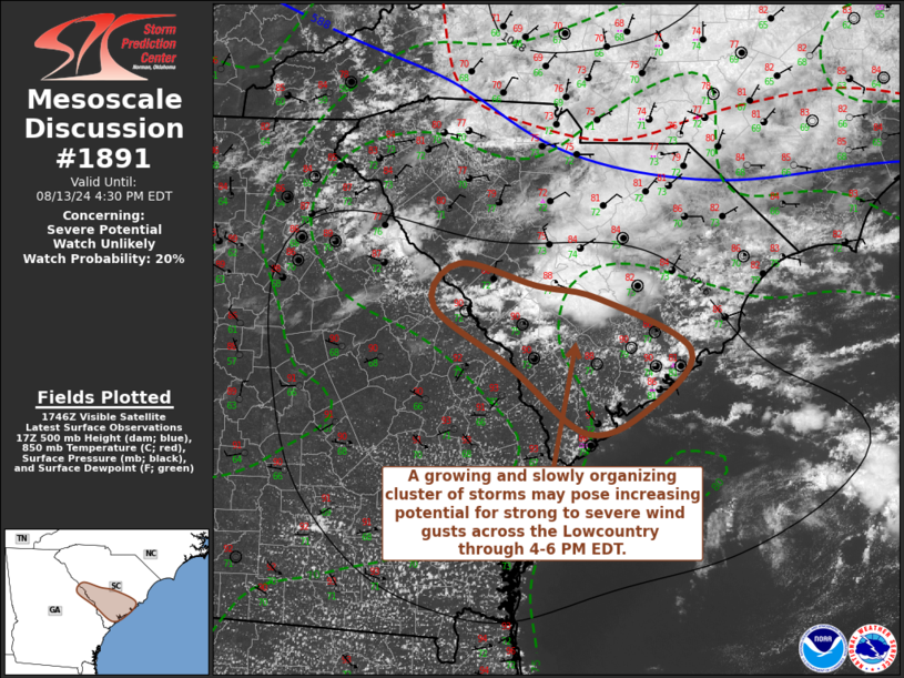
   SUMMARY...A growing and gradually organizing cluster of storms may
   pose increasing risk for potentially damaging wind gusts across the
   South Carolina Lowcountry through 4-6 PM EDT.

   DISCUSSION...Thunderstorms have recently begun to intensify in a
   small cluster along a strengthening surface cold pool now south of
   the Columbia area.  This is occurring beneath modest (including
   around 30 kt near 500 mb) west-northwesterly mid/upper flow, and
   along a weak south-southwestward advancing front to the lee of the
   southern Appalachians.  The frontal zone extends eastward into
   coastal areas northeast of Charleston, and is forecast to slowly
   approach the Savannah area through late afternoon.

   Although forecast soundings across this region exhibit notable
   relative warmth, and weak lapse rates, within a layer roughly from
   700-500 mb, seasonably high boundary-layer moisture content
   (including lower/mid 70s F dew points) along the front appears to be
   contributing to sizable mixed-layer CAPE on the order of 2000+ J/kg
   with insolation.  As modest low-level inflow and lift along the
   strengthening surface cold pool continue to overcome the inhibition,
    further upscale convective growth appears possible across the
   Lowcountry vicinity of South Carolina through 20-22Z.  Gradually,
   this may be accompanied by strengthening rear inflow and potential
   for strong to severe surface gusts, despite the weak low-level
   ambient wind fields.

   ..Kerr/Mosier.. 08/13/2024

   ...Please see www.spc.noaa.gov for graphic product...

   ATTN...WFO...CHS...CAE...

   LAT...LON   33598124 33488060 33037966 32538008 32318073 32888151
               33418229 33778204 33598124
|
|
Top/All Mesoscale Discussions/Forecast Products/Home
|
|


