|
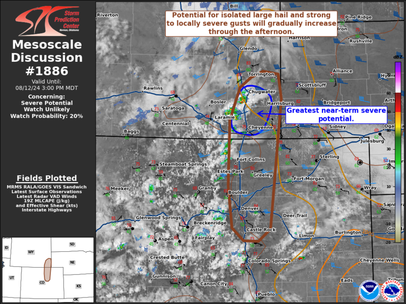
| Mesoscale Discussion 1886 |
|
< Previous MD Next MD >
|

|
   Mesoscale Discussion 1886
   NWS Storm Prediction Center Norman OK
   0205 PM CDT Mon Aug 12 2024

   Areas affected...Portions of southeastern Wyoming into
   northeast/north-central Colorado

   Concerning...Severe potential...Watch unlikely

   Valid 121905Z - 122100Z

   Probability of Watch Issuance...20 percent

   SUMMARY...The potential for isolated large hail and strong to
   locally severe gusts will gradually increase through the afternoon.
   The overall severe threat appears too marginal/localized for a
   watch.

   DISCUSSION...Latest day cloud phase satellite imagery indicates
   deepening boundary-layer cumulus along the Front Range and northward
   along the higher terrain into southeastern WY. Isolated
   thunderstorms have initiated in southeastern WY, where diurnal
   heating has eroded inhibition locally. Over the next several hours,
   continued heating amid upper 50s/lower 60s dewpoints should favor
   additional thunderstorm development along the higher terrain, before
   spreading eastward into the richer boundary-layer moisture.
   Sufficient (albeit weak) surface-based instability and effective
   shear increasing to around 30-40 kt could promote a few organized
   storms, including the potential for a supercell or two. Severe hail
   (generally up to 1.5 inches) and strong to locally severe gusts are
   possible with any longer-lived storms. However, current thinking is
   that the severe risk will be too localized/marginal for a watch.

   ..Weinman/Mosier.. 08/12/2024

   ...Please see www.spc.noaa.gov for graphic product...

   ATTN...WFO...BOU...CYS...

   LAT...LON   41330521 41880499 42050473 42160446 42120411 41690403
               39440430 39220457 39240489 39450515 40190525 41330521
|
|
Top/All Mesoscale Discussions/Forecast Products/Home
|
|


