|
| Mesoscale Discussion 1884 |
|
< Previous MD Next MD >
|

|
   Mesoscale Discussion 1884
   NWS Storm Prediction Center Norman OK
   0747 PM CDT Sun Aug 11 2024

   Areas affected...West-central Nebraska...Northwest Kansas

   Concerning...Severe Thunderstorm Watch 619...

   Valid 120047Z - 120245Z

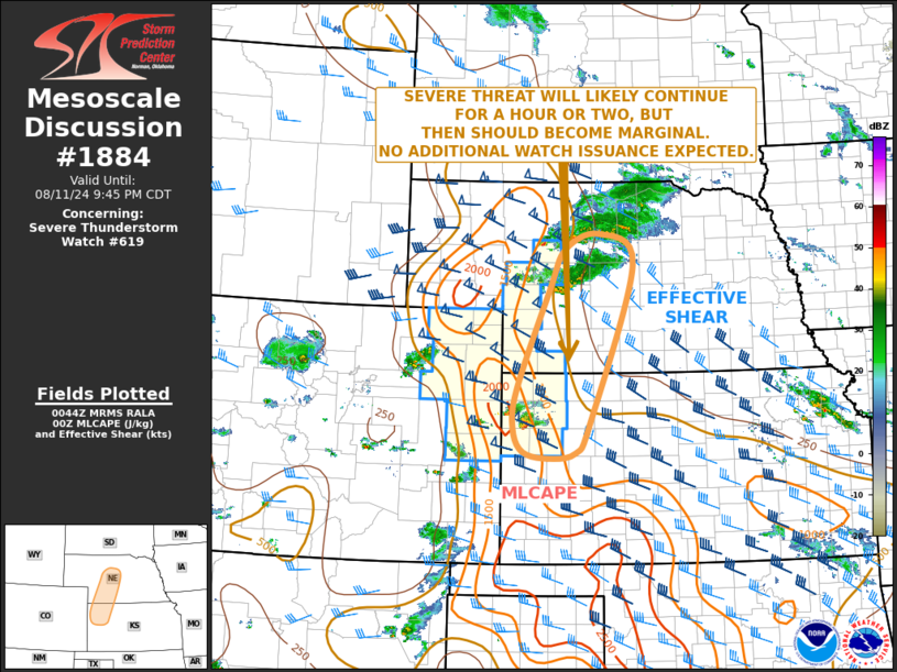
   The severe weather threat for Severe Thunderstorm Watch 619
   continues.

   SUMMARY...A threat for isolated large hail and severe wind gusts
   will likely continue for an hour or two, before becoming marginal.
   No additional weather watch issuance is expected.

   DISCUSSION...Mosaic radar imagery shows scattered to widely
   scattered strong to severe storms located from north-central
   Nebraska into far northwest Kansas. The storms are located to the
   east of an axis of moderate instability, where the RAP has MLCAPE in
   the 1000 to 2000 J/kg range. This, combined with moderate deep-layer
   shear, evident on regional WSR-88D VWPs, will continue to be
   favorable for severe storms over the next couple of hours. Severe
   wind gusts and isolated large hail will be the primary threats.
   However, the storms will move eastward into the central Plains,
   where instability is weaker and a capping inversion is present. This
   will result in a gradual weakening trend during the mid to late
   evening.

   ..Broyles.. 08/12/2024

   ...Please see www.spc.noaa.gov for graphic product...

   ATTN...WFO...GID...LBF...DDC...GLD...

   LAT...LON   42180005 41940074 41300108 39750174 39120182 38760162
               38660110 38730055 39220024 41709934 42180005
|
|
Top/All Mesoscale Discussions/Forecast Products/Home
|
|


