|
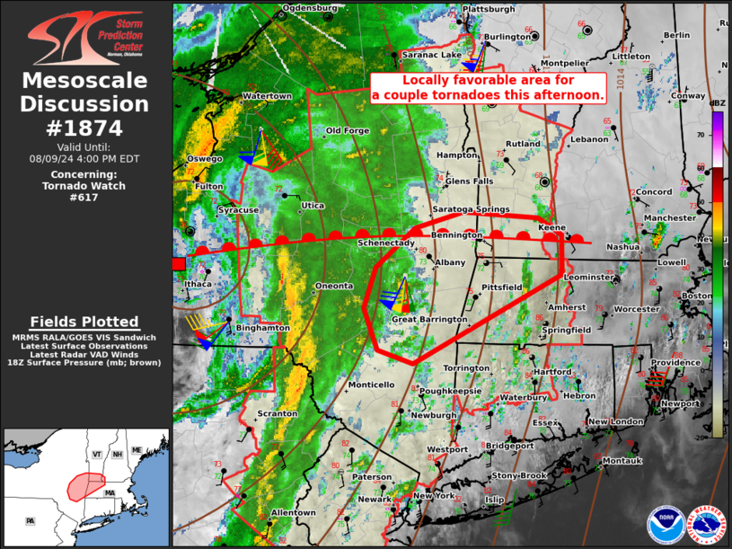
| Mesoscale Discussion 1874 |
|
< Previous MD Next MD >
|

|
   Mesoscale Discussion 1874
   NWS Storm Prediction Center Norman OK
   0127 PM CDT Fri Aug 09 2024

   Areas affected...Portions of southeastern NY...western MA...and
   southern VT

   Concerning...Tornado Watch 617...

   Valid 091827Z - 092000Z

   The severe weather threat for Tornado Watch 617 continues.

   SUMMARY...Within Tornado Watch 617, a potentially favorable corridor
   for a couple tornadoes is evident from southeastern NY into western
   MA and southern VT this afternoon.

   DISCUSSION...Latest visible satellite imagery indicates filtered
   diurnal heating (temperatures climbing into the upper 70s/lower 80s)
   within small cloud breaks in the vicinity of an east/west-oriented
   warm front moving slowly northward across southeastern NY to near MA
   and VT. Given the high-PW/tropical airmass in place, this heating
   may yield sufficient (albeit weak) MLCAPE for a couple low-topped,
   surface-based showers/storms this afternoon. Any convection that can
   root in the boundary layer may evolve into low-topped supercells,
   aided by strong deep-layer flow/shear associated with Post-Tropical
   Cyclone Debby.

   Additionally, the aforementioned corridor will be located beneath
   the core of a northward-advancing low-level jet during peak heating
   -- on the eastern periphery of the most substantial surface-pressure
   falls. Here, large, clockwise-curved/sickle-shaped hodographs
   (around 400 m2/s2 0-500m SRH per KENX VWP), will conditionally
   support a couple tornadoes with the more robust surface-based
   convection.

   ..Weinman.. 08/09/2024

   ...Please see www.spc.noaa.gov for graphic product...

   ATTN...WFO...GYX...BOX...ALY...BGM...

   LAT...LON   42657438 42987395 43107341 43057259 42917233 42607233
               41887396 41987435 42327450 42657438
|
|
Top/All Mesoscale Discussions/Forecast Products/Home
|
|


