|
| Mesoscale Discussion 1873 |
|
< Previous MD Next MD >
|
|
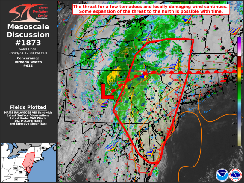
   Mesoscale Discussion 1873
   NWS Storm Prediction Center Norman OK
   0926 AM CDT Fri Aug 09 2024

   Areas affected...Parts of MD/DE/NJ...eastern PA...central/eastern NY

   Concerning...Tornado Watch 616...

   Valid 091426Z - 091600Z

   The severe weather threat for Tornado Watch 616 continues.

   SUMMARY...Some threat for locally damaging wind and a couple
   tornadoes will continue through the morning. Some expansion of the
   threat to the north is possible with time.

   DISCUSSION...Relatively shallow but strongly sheared convection is
   ongoing from parts of the Mid Atlantic into the Northeast, to the
   east of P.T.C. Debby. Area VWPs indicate that the stronger
   low/midlevel wind field is translating northward in association with
   Debby's fast-moving circulation, with weakening flow noted from KAKQ
   and KLWX, but strengthening flow farther to the northeast.

   A warm front extending east/northeast of Debby will translate
   northward through the day, though its progress may be slowed to some
   extent by widespread cloudiness/precipitation. Near and south of the
   warm front, tropical moisture  will support MLCAPE of 500-1000 J/kg,
   with locally greater buoyancy possible where some filtered heating
   is ongoing from eastern PA into NJ and southeast NY. Very weak
   midlevel lapse rates may continue to limit updraft intensity and
   organization to some extent, but strong low/midlevel flow and 0-1 km
   SRH of 200-300 m2/s2 (locally greater near the surface low and warm
   front) will support potential for rotation with the stronger cells
   and line segments.

   A few tornadoes remain possible from late this morning into the
   afternoon, along with some potential for convectively enhanced wind
   damage. Some threat may eventually spread north of WW 616 in
   conjunction with the warm front, and additional watch issuance is
   possible later today.

   ..Dean/Goss.. 08/09/2024

   ...Please see www.spc.noaa.gov for graphic product...

   ATTN...WFO...BTV...OKX...ALY...PHI...BGM...AKQ...BUF...CTP...
   LWX...

   LAT...LON   39367704 40257779 41387716 42677658 43207590 43397466
               43367351 43337314 42527342 42087346 41707358 39847439
               38727497 38227511 38027526 38037577 38357627 39027679
               39367704
|
|
Top/All Mesoscale Discussions/Forecast Products/Home
|
|


 @NWSSPC