|
| Mesoscale Discussion 1871 |
|
< Previous MD Next MD >
|

|
   Mesoscale Discussion 1871
   NWS Storm Prediction Center Norman OK
   1004 PM CDT Thu Aug 08 2024

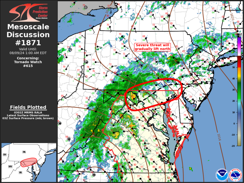
   Areas affected...Middle Atlantic

   Concerning...Tornado Watch 615...

   Valid 090304Z - 090500Z

   The severe weather threat for Tornado Watch 615 continues.

   SUMMARY...Severe threat will gradually spread into extreme southern
   Pennsylvania over the next several hours. However, this threat will
   be limited by weaker buoyancy.

   DISCUSSION...Tropical warm sector is gradually advancing north
   across the Delmarva, per mid 70s surface dew points approaching
   southeast PA. Latest diagnostic data suggests a fairly well-defined
   boundary extends from central NJ-extreme southeast PA-northern VA.
   Low-level shear has also increased at CCX where 0-3km SRH is now
   around 350 m2/s2. Strongest updrafts have been confined to the
   tropical warm sector and this will likely continue as buoyancy is
   quite limited north of the boundary. Given the poor lapse rates, it
   appears mid 70s dew points may be necessary for robust, longer-lived
   updrafts. If/until this air mass spreads north, confidence is not
   particularly high enough to warrant a new tornado watch. However,
   will continue to monitor this transition zone for recovery north of
   ww615.

   ..Darrow.. 08/09/2024

   ...Please see www.spc.noaa.gov for graphic product...

   ATTN...WFO...PHI...CTP...LWX...

   LAT...LON   39717828 40157663 40057569 39487574 39137695 38977813
               39717828
|
|
Top/All Mesoscale Discussions/Forecast Products/Home
|
|


