|
| Mesoscale Discussion 1863 |
|
< Previous MD Next MD >
|

|
   Mesoscale Discussion 1863
   NWS Storm Prediction Center Norman OK
   0119 AM CDT Thu Aug 08 2024

   Areas affected...Eastern NC

   Concerning...Tornado Watch 612...

   Valid 080619Z - 080815Z

   The severe weather threat for Tornado Watch 612 continues.

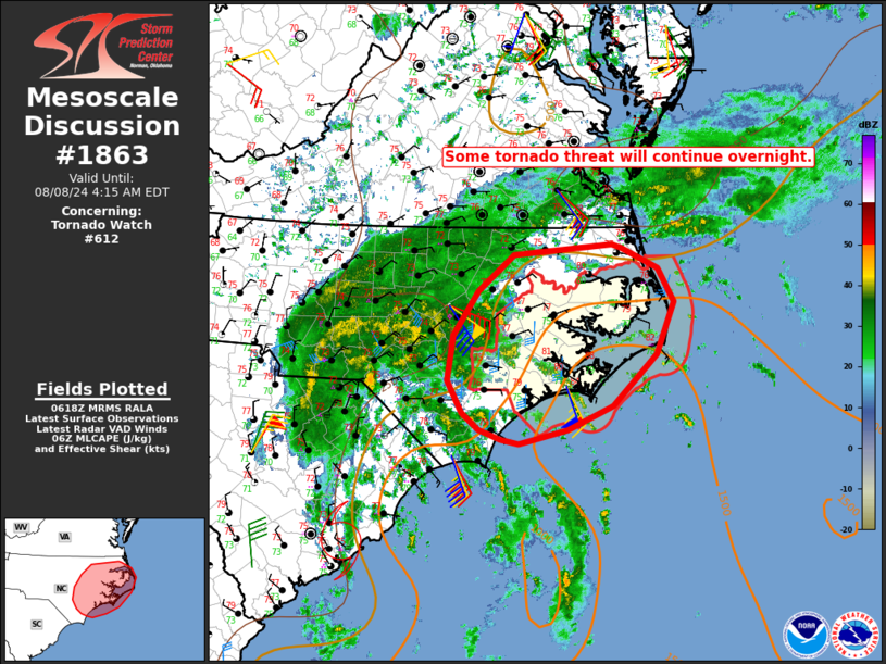
   SUMMARY...Some tornado threat will continue overnight. New watch
   issuance to the west of WW 612 is possible.

   DISCUSSION...Occasional small supercells have been redeveloping
   across parts of eastern NC early this morning, within an environment
   characterized by rich tropical moisture and relatively strong
   low-level shear/SRH (with 0-1 km SRH near 200 m2/s2 per the KMHX
   VWP). This process may continue through the overnight, as convection
   continues to spread inland within the northeast quadrant of Tropical
   Storm Debby, with an attendant tornado threat.

   Thus far, the western extent of the threat has been limited by an
   extensive rain shield further inland across parts of central/eastern
   NC. However, this rain shield may tend to shift somewhat westward
   with time, with potential for some destabilization and an increasing
   tornado threat to the west of WW 612. New watch issuance is possible
   in order to address the potentially expanding threat.

   ..Dean/Edwards.. 08/08/2024

   ...Please see www.spc.noaa.gov for graphic product...

   ATTN...WFO...AKQ...MHX...RAH...ILM...

   LAT...LON   34267806 34467830 34827849 35327842 35837807 36237759
               36357623 36327611 36087561 35707538 35127562 34547622
               34277685 34117752 34157777 34267806
|
|
Top/All Mesoscale Discussions/Forecast Products/Home
|
|


