|
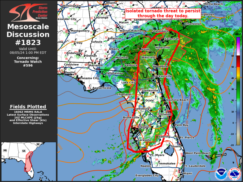
| Mesoscale Discussion 1823 |
|
< Previous MD Next MD >
|

|
   Mesoscale Discussion 1823
   NWS Storm Prediction Center Norman OK
   1108 AM CDT Mon Aug 05 2024

   Areas affected...far southern South Carolina...Southeast
   Georgia...central and northeast Florida

   Concerning...Tornado Watch 596...

   Valid 051608Z - 051700Z

   CORRECTED FOR INCORRECT OCEAN REFERENCE

   The severe weather threat for Tornado Watch 596 continues.

   SUMMARY...Isolated tornado threat will persist through the day
   today.

   DISCUSSION...Tropical Storm Debby is slowly moving north through
   portions of northwest Florida. An extensive region of banded
   precipitation extends from the eastern eyewall into the western
   Atlantic and across the Florida Peninsula. Instability has been
   mostly weak amid persistent stratiform rain across northeast Florida
   and southeast Georgia. Greater instability has developed with more
   broken cloudcover across central Florida where lightning activity
   has been focused. However, surface winds are veered in this region
   and thus, the tornado threat is somewhat muted.

   The wind profile sampled by the JAX VWP remains quite favorable for
   low-level updraft organization and tornado potential. If greater
   instability can develop along the coast later today, an increasing
   tornado threat is possible from southeast Georgia into eastern South
   Carolina as the wind field expands northward.

   ..Bentley.. 08/05/2024

   ...Please see www.spc.noaa.gov for graphic product...

   ATTN...WFO...CHS...MLB...TBW...JAX...

   LAT...LON   31528246 32398147 32608068 32448025 31988026 30978087
               30068110 29378084 28638068 27938094 27158128 26898194
               26868258 27048301 27918297 28908264 30038256 31528246
|
|
Top/All Mesoscale Discussions/Forecast Products/Home
|
|


