|
| Mesoscale Discussion 1815 |
|
< Previous MD Next MD >
|

|
   Mesoscale Discussion 1815
   NWS Storm Prediction Center Norman OK
   1247 PM CDT Sun Aug 04 2024

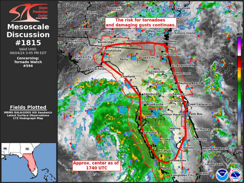
   Areas affected...much of the Florida Peninsula and far southern
   Georgia

   Concerning...Tornado Watch 594...

   Valid 041747Z - 041945Z

   The severe weather threat for Tornado Watch 594 continues.

   SUMMARY...Mini supercells within the outer bands of intensifying TC
   Debby will remain capable of tornadoes this afternoon.

   DISCUSSION...As of 1745 UTC, the latest NHC Aircraft recon fixed the
   low-level center of TS Debby near 27.0 N, 84.3 W. As the TC
   continues to deepen, low-level hodograph expansion has been noted at
   most of the radar sites east/northeast of the center. A few
   tornadoes are possible with miniature supercells embedded within the
   spiral rain bands as they move ashore into moderate low-level SRH.
   Stronger low-level mesocyclones within the most westward band have
   moved offshore over the past few hours, but a new band developing to
   the east has shown some stronger convective development recently. As
   low-level shear continues to intensify, tornado potential should
   increase, especially where low-level flow is more backed. Warmer
   surface temperatures to the north of the main cloud shield may also
   support more intense convection and a locally greater tornado or
   damaging gust risk this afternoon.

   ..Lyons.. 08/04/2024

   ...Please see www.spc.noaa.gov for graphic product...

   ATTN...WFO...MFL...MLB...TBW...JAX...TAE...

   LAT...LON   26378186 26958227 27618259 28778267 29468327 30138435
               30688414 30788356 30848219 30778159 30168131 29288102
               28358068 27928072 27318071 26408115 26278154 26378186
|
|
Top/All Mesoscale Discussions/Forecast Products/Home
|
|


