|
| Mesoscale Discussion 1813 |
|
< Previous MD Next MD >
|

|
   Mesoscale Discussion 1813
   NWS Storm Prediction Center Norman OK
   0932 AM CDT Sun Aug 04 2024

   Areas affected...portions of the western and central Florida
   Peninsula

   Concerning...Severe potential...Tornado Watch likely

   Valid 041432Z - 041600Z

   Probability of Watch Issuance...95 percent

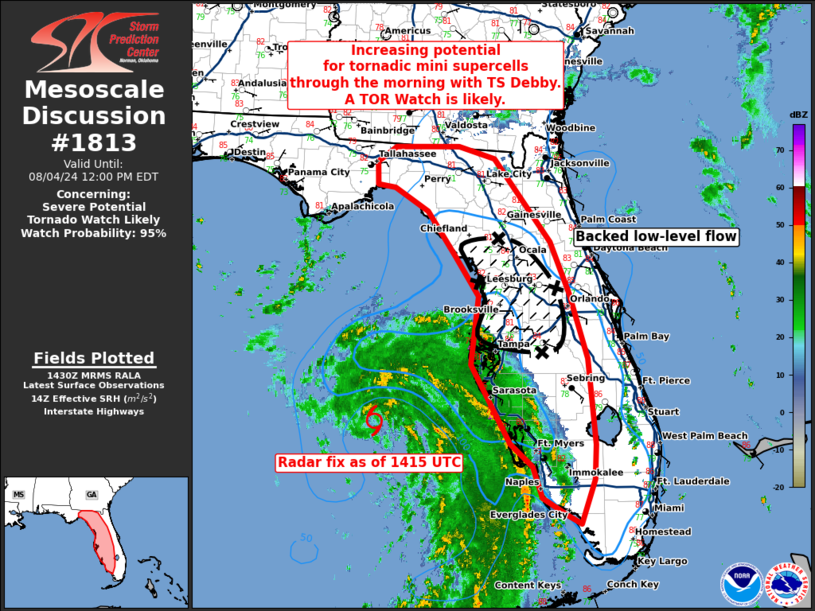
   SUMMARY...Increasing diurnal heating on the outer envelope of
   intensifying TC Debby will likely support supercell development
   through much of the Day. Intensifying low-level shear may support a
   few tornadoes. A new Tornado Watch is likely.

   DISCUSSION...As of 1425 UTC, regional radar analysis placed the
   developing center of intensifying TC Debby approximately 105 nm
   west-southwest of KTBW. Latest NHC projections show continued
   intensification of the system west of the FL Peninsula. To the east
   of the main envelope of the TC, diurnal heating has commenced inland
   with temperatures warming into the mid 80s F. As heating continues,
   moderate buoyancy will likely support the development of scattered
   thunderstorms on the outer convergence bands. As the TC deepens,
   low-level wind fields should intensify through the morning and early
   afternoon. area VADs already show 0-1km SRH around 200-250 m2/s2
   with weak mesocyclones noted within some of the stronger convective
   elements. As low-level shear intensifies, continued low-level
   updraft rotation appears probable with mini supercell structures. A
   few tornadoes are likely as storms intensify within the deepening
   buoyancy and stronger shear regime.

   Model guidance and observational trends suggest tornado potential is
   highest where the low-level flow retains the most easterly
   component, roughly along and north of the I-4 corridor later today.
   However, given the expected intensification of Debby, tornadoes will
   be possible across much of the western and central Peninsula as the
   bands move onshore and encounter stronger shear/buoyancy. Given the
   increasing risk for tornadoes, a Tornado Watch will likely be
   needed.

   ..Lyons/Hart.. 08/04/2024

   ...Please see www.spc.noaa.gov for graphic product...

   ATTN...WFO...MFL...MLB...TBW...JAX...TAE...

   LAT...LON   25778137 26018176 26418191 26728223 27758282 28658270
               29208306 29778348 30088398 30128424 30438424 30638396
               30638301 30478247 29388163 28708135 27838109 26708098
               26248100 25668119 25778137
|
|
Top/All Mesoscale Discussions/Forecast Products/Home
|
|


