|
| Mesoscale Discussion 1790 |
|
< Previous MD Next MD >
|

|
   Mesoscale Discussion 1790
   NWS Storm Prediction Center Norman OK
   0315 PM CDT Thu Aug 01 2024

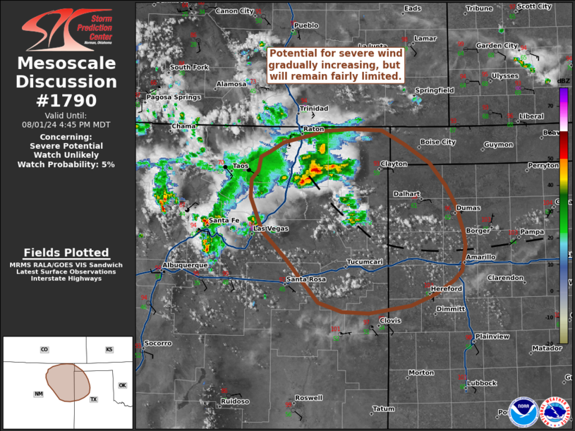
   Areas affected...Northeast New Mexico into the western Oklahoma and
   Texas Panhandles

   Concerning...Severe potential...Watch unlikely

   Valid 012015Z - 012245Z

   Probability of Watch Issuance...5 percent

   SUMMARY...Thunderstorm coverage away from higher terrain is slowly
   increasing across northeastern New Mexico and portions of the
   western OK/TX Panhandles. Thermodynamic conditions are favorable for
   strong to severe outflow winds.

   DISCUSSION...Thunderstorms have been ongoing for much of the
   afternoon within the Sangre de Cristo mountains and Raton Mesa
   within a weak upslope flow regime, but have remained relatively
   benign. However, more recent convective initiation is noted along a
   subtle surface trough/confluence zone draped to the southeast across
   northeast NM into the TX Panhandle. Temperatures climbing into the
   upper 90s and low 100s are eroding any lingering MLCIN, which should
   continue to support isolated to scattered thunderstorm development
   along the surface boundary over the next few hours. These hot
   conditions are driving dewpoint depressions upwards of 30-50 F,
   implying that a deep, well-mixed boundary layer is in place across
   the region - especially along and south of the boundary - that will
   promote strong downdraft accelerations. Weak flow aloft will limit
   storm organization and longevity, but strong to severe outflow winds
   appear possible.

   Some recent CAM solutions hint that a cold-pool driven cluster may
   emerge across northeast NM later this afternoon/evening and
   propagate to the southeast. This would pose a somewhat more
   widespread wind threat, but this scenario is conditional on
   achieving sufficient convective coverage and cold pool amalgamation.
   Other solutions suggest that a storm or two may migrate far enough
   east to intensify within a more moist/buoyant air mass. However,
   this potential appears limited given a high likelihood for the
   development of undercutting outflows. Given low confidence in these
   scenarios, watch issuance is not anticipated.

   ..Moore/Bunting.. 08/01/2024

   ...Please see www.spc.noaa.gov for graphic product...

   ATTN...WFO...LUB...AMA...ABQ...

   LAT...LON   36600508 36660494 36790471 36890427 36930410 36960361
               36940314 36770277 36520237 36230212 35970195 35610184
               35430181 35110186 34980199 34810229 34650268 34560334
               34580378 34690415 34950440 35250467 35630505 36060525
               36300524 36410513 36600508
|
|
Top/All Mesoscale Discussions/Forecast Products/Home
|
|


