|
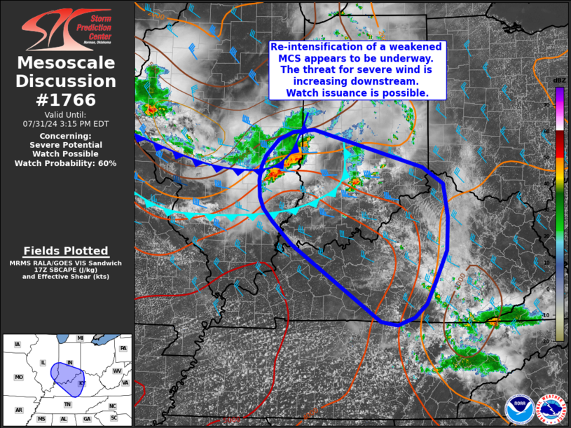
| Mesoscale Discussion 1766 |
|
< Previous MD Next MD >
|

|
   Mesoscale Discussion 1766
   NWS Storm Prediction Center Norman OK
   1219 PM CDT Wed Jul 31 2024

   Areas affected...Southeast Illinois into southern Indiana and
   central Kentucky

   Concerning...Severe potential...Watch possible

   Valid 311719Z - 311915Z

   Probability of Watch Issuance...60 percent

   SUMMARY...Re-intensification of a weak MCS appears to be underway
   across southeast Illinois and southern Indiana. The threat for
   severe winds may increase over the next few hours downstream into
   Kentucky. A watch may be needed this afternoon.

   DISCUSSION...Over the past 30-45 minutes, GOES one-minute imagery
   shows gradual but persistent convective development along the
   leading edge of an outflow boundary associated with a weak MCS
   across southern IN. Additionally, steadily intensifying convection
   is noted across southeast IL. Temperatures ahead of the southeast IL
   convection (and immediately behind the primary outflow boundary)
   remain in the low 80s, which should still support buoyant parcels
   rooted near the surface per modified RAP forecast soundings. This
   also implies that the deeper cold pool remains further northwest
   across southeast IL where temperatures are in the mid-70s. These
   trends suggest that gradual re-intensification of the MCS may be
   underway.

   West/southwesterly flow across the lower OH River Valley is
   advecting a plume of higher theta-e air (characterized by
   temperatures in the upper 80s with mid-70s dewpoints)
   east/northeastward immediately downstream of the MCS. The
   west/southwesterly low-level winds, coupled with steady 25-30 knot
   northwesterly flow aloft, are supporting effective bulk shear values
   on the order of 25-30 knots. Given an improving thermodynamic
   environment and adequate wind shear, the recent intensification
   trend should continue with an attendant increase in severe wind
   potential (with an isolated large hail threat with more discrete
   leading cells) over the next several hours as the MCS continues to
   move generally southeast. It is unclear how far southeast this
   threat will persist given a residual cold pool from prior convection
   across eastern KY and northeast TN, but watch issuance may be
   necessary as the MCS continues to re-intensify.

   ..Moore/Gleason.. 07/31/2024

   ...Please see www.spc.noaa.gov for graphic product...

   ATTN...WFO...JKL...ILN...LMK...OHX...IND...PAH...ILX...

   LAT...LON   39848727 39208495 38928451 38368442 37818445 37288470
               36918489 36698514 36568549 36628585 37918773 38298815
               38518835 38698843 38978845 39208841 39408830 39678803
               39798772 39848727
|
|
Top/All Mesoscale Discussions/Forecast Products/Home
|
|


