|
| Mesoscale Discussion 1765 |
|
< Previous MD Next MD >
|

|
   Mesoscale Discussion 1765
   NWS Storm Prediction Center Norman OK
   1147 AM CDT Wed Jul 31 2024

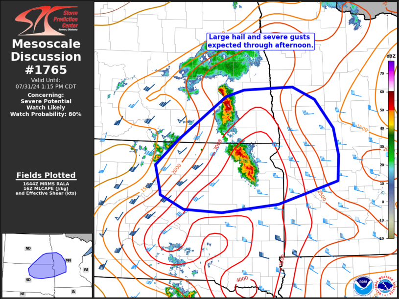
   Areas affected...northeast SD and southeast ND into west-central MN

   Concerning...Severe potential...Watch likely

   Valid 311647Z - 311815Z

   Probability of Watch Issuance...80 percent

   SUMMARY...Thunderstorm clusters will pose a risk for large hail (up
   to 2 inch diameter) and severe gusts to 75 mph into the afternoon
   hours. A severe thunderstorm watch will likely be needed soon.

   DISCUSSION...Thunderstorm clusters across southeast ND/northeast SD
   have intensified over the past hour or so as the airmass continues
   to destabilize. A corridor of strong instability is noted across the
   discussion area, though some lingering MLCIN likely resulting in
   slighted elevated convection. With additional heating and increasing
   ascent, inhibition should erode over the next couple of hours, with
   further destabilization expected downstream into western/central MN.
   Favorable vertical shear, with effective shear magnitudes greater
   than 35 kt, will support continued storm organization. Furthermore,
   very steep midlevel lapse rates around 8-8.5 C/km are present across
   this area. Favorable thermodynamics and elongated hodographs suggest
   large to very large hail is possible. As convection become surface
   based, an increasing risk for severe gusts to 75 mph will accompany
   this activity.

   Additional convection is expected to develop further southwest near
   a surface low and cold front. This activity may initially be
   supercellular, also posing a risk of very large hail and significant
   wind gusts. However, upscale development may occur quickly given
   linear forcing tied to the front. A severe thunderstorm watch will
   likely be needed soon.

   ..Leitman/Gleason.. 07/31/2024

   ...Please see www.spc.noaa.gov for graphic product...

   ATTN...WFO...MPX...FGF...FSD...ABR...BIS...

   LAT...LON   45119481 44639661 44449831 44519944 44800016 44920018
               45440033 45989965 46939820 47079764 47129614 46869546
               46249491 45669476 45119481
|
|
Top/All Mesoscale Discussions/Forecast Products/Home
|
|


