|
| Mesoscale Discussion 1723 |
|
< Previous MD Next MD >
|

|
   Mesoscale Discussion 1723
   NWS Storm Prediction Center Norman OK
   0900 PM CDT Sun Jul 28 2024

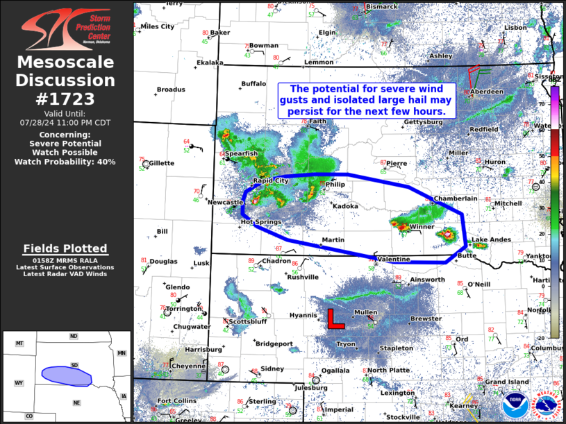
   Areas affected...Portions of southern South Dakota into far
   north-central Nebraska

   Concerning...Severe potential...Watch possible

   Valid 290200Z - 290400Z

   Probability of Watch Issuance...40 percent

   SUMMARY...The potential for a few severe wind gusts and isolated
   large hail may persist across portions of southern South Dakota into
   far north-central Nebraska for the next few hours. The need for a
   watch is still uncertain.

   DISCUSSION...As of 0150Z, thunderstorms have recently increased in
   coverage and intensity across portions of southwestern South Dakota
   -- where a large cold pool has developed. These storms are beginning
   to intercept a plume of post-frontal/recycled boundary-layer
   moisture (lower/middle 60s dewpoints) north of a surface low
   centered over central Nebraska. Steep midlevel lapse rates (sampled
   by regional 00Z soundings) above the destabilized boundary layer
   could support the maintenance or perhaps intensification of these
   storms as they continue east-southeastward during the next few
   hours. And, a long/straight hodograph (around 45 kt of 0-6km shear
   per the KUDX VWP) will conditionally support organized convection,
   including the potential for supercell structures and/or line
   segments. Isolated large hail (some possibly very large) and severe
   gusts are possible with any longer-lived storms.

   Generally weak large-scale ascent and gradually increasing nocturnal
   stability cast uncertainty on the overall coverage of severe threat.
   Therefore, convective trends will be monitored closely.

   ..Weinman/Hart.. 07/29/2024

   ...Please see www.spc.noaa.gov for graphic product...

   ATTN...WFO...FSD...ABR...LBF...UNR...

   LAT...LON   43230243 43430308 43630341 43840341 43980334 44150299
               44220250 44270187 44270115 44069983 43629870 43139863
               42879907 42890016 43230243
|
|
Top/All Mesoscale Discussions/Forecast Products/Home
|
|


