|
| Mesoscale Discussion 1716 |
|
< Previous MD Next MD >
|
|
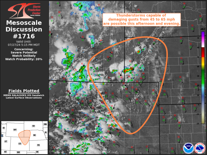
   Mesoscale Discussion 1716
   NWS Storm Prediction Center Norman OK
   0416 PM CDT Sat Jul 27 2024

   Areas affected...Northeast CO...Far Southeast WY...NE Panhandle

   Concerning...Severe potential...Watch unlikely

   Valid 272116Z - 272315Z

   Probability of Watch Issuance...20 percent

   SUMMARY...Thunderstorms capable of damaging gusts from 45 to 65 mph
   are possible from southeast Wyoming and northeast CO into the
   Nebraska Panhandle this afternoon and evening.

   DISCUSSION...A few deeper updrafts have recently developed across
   extreme southeast WY and the southwestern NE Panhandle over the past
   half hour or so. These deeper updrafts are developing in an area of
   modest buoyancy, increasing large-scale forcing for ascent, and
   persistent low-level convergence. The deeply mixed boundary layer in
   place will support an outflow-dominant storm mode, with the area of
   convergence downstream northeastward into the northern NE Panhandle
   and south-central SD potentially acting as a favored corridor for
   propagation. Damaging gusts from 45 to 65 mph are the primary severe
   hazard with these storms.

   Farther west, thunderstorms continue to develop over the higher
   terrain, with the enhanced mid-level flow taking these storms
   eastward into the deeply mixed boundary layer downstream. Vertical
   shear is modest, with a predominantly multicellular,
   outflow-dominant mode anticipated. Damaging gusts from 45 to 65 mph
   are the primary severe hazard with these storms as well.

   ..Mosier/Hart.. 07/27/2024

   ...Please see www.spc.noaa.gov for graphic product...

   ATTN...WFO...LBF...GLD...PUB...BOU...CYS...

   LAT...LON   38730373 40290531 41920612 42980330 42480154 40020227
               38730373
|
|
Top/All Mesoscale Discussions/Forecast Products/Home
|
|


 @NWSSPC