|
| Mesoscale Discussion 1699 |
|
< Previous MD Next MD >
|
|
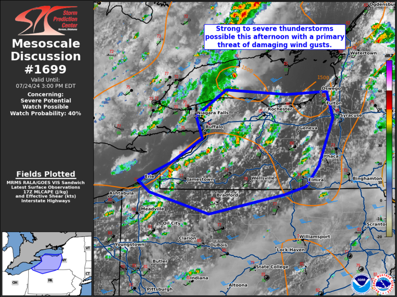
   Mesoscale Discussion 1699
   NWS Storm Prediction Center Norman OK
   1230 PM CDT Wed Jul 24 2024

   Areas affected...Western New York and far northern Pennsylvania

   Concerning...Severe potential...Watch possible

   Valid 241730Z - 241900Z

   Probability of Watch Issuance...40 percent

   SUMMARY...Strong to severe thunderstorms are possible this afternoon
   with a primary threat of damaging wind gusts.

   DISCUSSION...Scattered thunderstorms will continue to mature across
   western New York and northern Pennsylvania this afternoon. Continued
   heating and low-level moisture advection will increase instability
   this afternoon, peaking around 1500 to 2000 J/kg MLCAPE. The BUF VWP
   shows around 30 knots of effective shear which will support some
   updraft organization. Damaging wind gusts will be the primary threat
   with isolated large hail possible.

   A severe thunderstorm watch does not appear imminent, but if several
   stronger updrafts can congeal and mature, a small severe
   thunderstorm watch may be needed this afternoon/early evening.

   ..Bentley/Thompson.. 07/24/2024

   ...Please see www.spc.noaa.gov for graphic product...

   ATTN...WFO...BGM...BUF...CTP...CLE...

   LAT...LON   42047682 41927726 41637878 41957996 42128019 42407954
               42767891 43097905 43497844 43417721 43467639 43057626
               42357657 42047682
|
|
Top/All Mesoscale Discussions/Forecast Products/Home
|
|


 @NWSSPC