|
| Mesoscale Discussion 1694 |
|
< Previous MD Next MD >
|
|
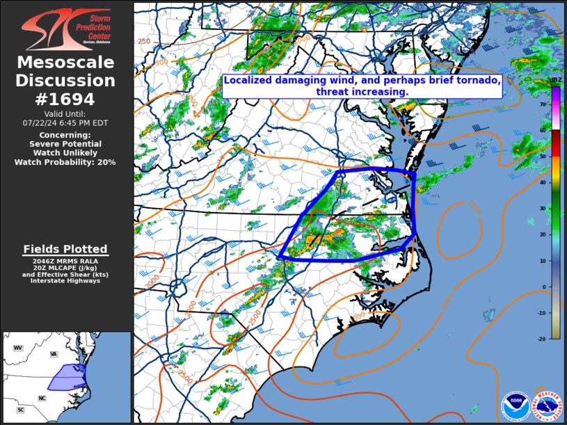
   Mesoscale Discussion 1694
   NWS Storm Prediction Center Norman OK
   0349 PM CDT Mon Jul 22 2024

   Areas affected...Portions of northeastern North Carolina and far
   southeastern Virginia

   Concerning...Severe potential...Watch unlikely

   Valid 222049Z - 222245Z

   Probability of Watch Issuance...20 percent

   SUMMARY...A localized damaging wind threat is increasing across
   portions of northeastern NC and far southeastern VA. A brief tornado
   also cannot be ruled out.

   DISCUSSION...Regional radar imagery shows a cluster of thunderstorms
   beginning to merge across northeastern NC. Additional thunderstorms
   were also developing along a differential heating boundary near the
   far eastern NC/VA border. These storms are an environment
   characterized by a moderately buoyant airmass and modest deep layer
   effective shear, under a belt of relatively stronger mid to upper
   level southwesterly flow. Continued cell mergers over the next 1-2
   hours will have the opportunity to produce damaging wind gusts. In
   addition, slowly increasing low-level flow may result in a localized
   increase of helicity near the aforementioned boundary through early
   this evening, and thunderstorms exhibiting more supercell like
   structures may have the opportunity to produce a brief tornado
   before the onset of nocturnal stabilization. Given the very
   localized nature of the severe threat, however, a WW is not
   anticipated at this time.

   ..Barnes/Smith.. 07/22/2024

   ...Please see www.spc.noaa.gov for graphic product...

   ATTN...WFO...AKQ...MHX...RAH...

   LAT...LON   37247578 37057582 36667583 36217580 35957610 35757710
               35757774 35767836 35817868 36537821 36967772 37297746
               37357674 37317619 37247578
|
|
Top/All Mesoscale Discussions/Forecast Products/Home
|
|


 @NWSSPC