|
| Mesoscale Discussion 1693 |
|
< Previous MD Next MD >
|
|
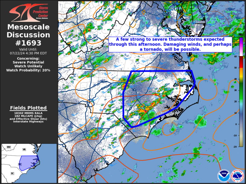
   Mesoscale Discussion 1693
   NWS Storm Prediction Center Norman OK
   0132 PM CDT Mon Jul 22 2024

   Areas affected...Central and eastern North Carolina

   Concerning...Severe potential...Watch unlikely

   Valid 221832Z - 222030Z

   Probability of Watch Issuance...20 percent

   SUMMARY...A few strong to severe thunderstorms are expected through
   late this afternoon across portions of central and eastern NC.
   Damaging wind gusts, and perhaps a tornado late this afternoon, will
   be possible.

   DISCUSSION...Latest visible satellite and radar imagery suggest an
   increase in moist convection is ongoing along a weakly convergent
   sea breeze and within subtle DCVA. This area is also under a belt of
   relatively stronger mid to upper level southwesterly flow, and near
   a moderate instability axis extending southwest to northeast.
   Dewpoints in the mid to upper 70s combined with temperatures in the
   mid to upper 80s are contributing to MLCAPE ~2000 J/kg. As
   destabilization continues through this afternoon, and effective
   shear remains around 30-35 kt, a few organized updrafts are
   anticipated. In addition, a modest increase in low-level flow late
   this afternoon near the northeastern NC coastline may result in some
   enhanced low-level helicity and the opportunity for a brief tornado.
   The main concern, however, will be damaging wind gusts via
   precipitation loading especially with any supercells that manage to
   develop and/or clusters contributing to deepening cold pools. Given
   the expected severe weather coverage, a WW is not anticipated at
   this time.

   ..Barnes/Smith.. 07/22/2024

   ...Please see www.spc.noaa.gov for graphic product...

   ATTN...WFO...AKQ...MHX...RAH...ILM...RNK...

   LAT...LON   34327849 34267878 34647918 35657920 36547882 36557626
               36547582 36107566 35927570 35077655 34847709 34327849
|
|
Top/All Mesoscale Discussions/Forecast Products/Home
|
|


 @NWSSPC