|
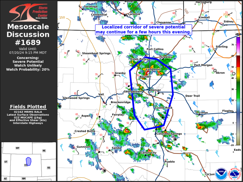
| Mesoscale Discussion 1689 |
|
< Previous MD Next MD >
|
|
   Mesoscale Discussion 1689
   NWS Storm Prediction Center Norman OK
   0919 PM CDT Sat Jul 20 2024

   Areas affected...portions of the Front Range of Colorado

   Concerning...Severe potential...Watch unlikely

   Valid 210219Z - 210315Z

   Probability of Watch Issuance...20 percent

   SUMMARY...A pair of supercells moving south along the I-25 corridor
   may pose a risk for hail and severe gusts for a couple more hours
   tonight. The longevity and spatial extent of the threat is
   uncertain.

   DISCUSSION...As of 0210 UTC, a pair of supercells have evolved
   within the upslope flow regime across eastern CO. These storms have
   produced reports of measured severe hail and wind gusts over the
   last hour. Extrapolation places these storms near Denver in the next
   hour. Around 1000 J/kg of MUCAPE and 35-40 kt of northerly
   deep-layer shear will remain sufficient for storm organization this
   evening. Some risk for severe hail and damaging gusts could continue
   as these storms track along and south of the Metro this evening. A
   complicating factor is the presence of westward surging outflow from
   prior convection over the adjacent plains. With the loss of diurnal
   heating and cooler surface temperatures post outflow, surface
   stabilization is expected. However, it remains unclear how long it
   will take for the decrease in instability to affect these storms.
   Convective trends are being monitored, but the severe risk could
   persist for another couple of hours in and south of the Denver metro
   before weakening later this evening.

   ..Lyons/Gleason.. 07/21/2024

   ...Please see www.spc.noaa.gov for graphic product...

   ATTN...WFO...PUB...BOU...

   LAT...LON   40310533 40460510 40410478 40200442 39690435 39050461
               39010472 38950511 39250538 40180552 40310533
|
|
Top/All Mesoscale Discussions/Forecast Products/Home
|
|


 @NWSSPC