|
| Mesoscale Discussion 1688 |
|
< Previous MD Next MD >
|
|
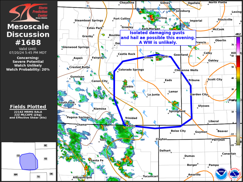
   Mesoscale Discussion 1688
   NWS Storm Prediction Center Norman OK
   0516 PM CDT Sat Jul 20 2024

   Areas affected...portions of southeast colorado and far southwest
   Kansas.

   Concerning...Severe potential...Watch unlikely

   Valid 202216Z - 202345Z

   Probability of Watch Issuance...20 percent

   SUMMARY...Damaging gusts and hail will be possible with isolated
   thunderstorms this evening. A WW appears unlikely though conditions
   will be monitored.

   DISCUSSION...As of 2210 UTC regional radar imagery showed isolated
   thunderstorms ongoing across the foothills of southeast CO and
   farther east over the High Plains. Over the last hour, storms have
   gradually increased in coverage and intensity within the weak
   northeasterly upslope flow regime. While not overly robust, modest
   mid-level lapse rates and 50s F dewpoints are supporting moderate
   buoyancy. Flow aloft is also not overly strong, but 25-30 kt of
   effective shear should be sufficient for brief storm organization
   with multicells and transient supercell structures.

   As storms continue to develop they should move off the higher
   terrain this evening. Isolated damaging gusts and some hail are
   possible with the stronger cores. However, storm organization
   appears transient and the lack of greater forcing aloft will keep
   coverage limited. This should keep the severe risk marginal and a WW
   is unlikely.

   ..Lyons/Gleason.. 07/20/2024

   ...Please see www.spc.noaa.gov for graphic product...

   ATTN...WFO...DDC...GLD...AMA...PUB...BOU...ABQ...

   LAT...LON   39420311 39350248 38340163 37210161 36950211 36880319
               37000450 37900496 38840497 39190460 39420311
|
|
Top/All Mesoscale Discussions/Forecast Products/Home
|
|


 @NWSSPC