|
| Mesoscale Discussion 1684 |
|
< Previous MD Next MD >
|
|
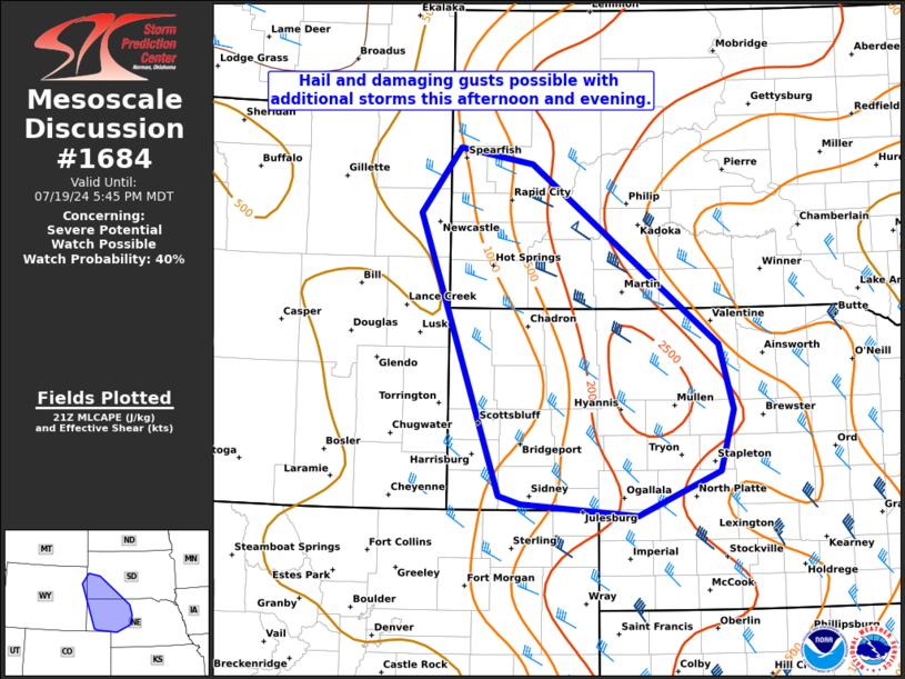
   Mesoscale Discussion 1684
   NWS Storm Prediction Center Norman OK
   0450 PM CDT Fri Jul 19 2024

   Areas affected...southwest South Dakota and west-central Nebraska

   Concerning...Severe potential...Watch possible

   Valid 192150Z - 192345Z

   Probability of Watch Issuance...40 percent

   SUMMARY...Thunderstorms should gradually increase in coverage and
   intensity this afternoon/evening. A risk for hail and damaging gusts
   may evolve. A WW is possible.

   DISCUSSION...As of 2140 UTC, regional radar and satellite imagery
   showed isolated thunderstorms developing near a frontal zone across
   southern SD, northern NE and eastern WY. Warming afternoon surface
   temperatures in the 80s to 90s F with 50s and 60s F dewpoints are
   supporting moderate buoyancy of 1500-2500 J/kg across southern SD
   and western NE. Enhanced mid-level flow ahead of a weak perturbation
   was observed on area VADs, with effective shear of 35-45 kt.
   Isolated organized storms, including supercells, appear possible
   given the favorable CAPE/shear overlap. While mid-level lapse rates
   are not overly steep (7-7.5 C/km), the moderate buoyancy and
   potential for updraft rotation suggest a risk for hail with the
   stronger storms. Damaging gusts are also possible with LCL heights
   above 2,000 m.

   Additional storm development/intensification will remain possible
   late this afternoon and into the evening as weak ascent continues to
   overspread the central High Plains. Exact storm coverage remains
   uncertain given the relatively narrow zone of buoyancy and cloud
   debris from earlier convection. Still, some CAM guidance suggests a
   cluster or storms may eventually evolve with the potential for hail
   and damaging winds across parts of southwest SD and west-central NE.
   While convective evolution and the degree of severe risk remains
   unclear, conditions will be monitored for a possible WW.

   ..Lyons/Gleason.. 07/19/2024

   ...Please see www.spc.noaa.gov for graphic product...

   ATTN...WFO...LBF...UNR...BOU...CYS...

   LAT...LON   41130338 43940444 44580391 44430294 42640044 41980025
               41370043 40930153 41050308 41130338
|
|
Top/All Mesoscale Discussions/Forecast Products/Home
|
|


 @NWSSPC