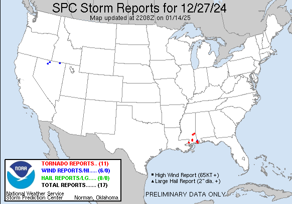
| Tornado Reports (CSV) (Raw Tornado CSV)(?) |
|---|
Time | | Location | County | State | Lat | Lon | Comments |
| 1350 | | 8 NNW Pearl River | St. Tammany | LA | 3048 | 8981 | Tornado touched down near the intersection of W Moran Rd and John Keller Dr causing half of a water oak to snap. It moved northeastward causing sporadic tree damage and (LIX) |
| 1542 | | 1 NNW Fruitland Park | Forrest | MS | 3093 | 8918 | Video on Facebook showed tornado crossing US Highway 49 north of Wiggins ... with a power flash occurring as the condensation funnel crossed the highway. Comments indica (JAN) |
| 2004 | | 2 S Dees | Mobile | AL | 3053 | 8835 | An EF1 tornado began south of Dees in Mobile County west of Grand Bay Wilmer Road. A radar indicated tornado debris signature began in the adjacent forest ... tracking n (MOB) |
| 2008 | | 1 S Dees | Mobile | AL | 3055 | 8834 | Tree debris strewn across Grand Bay/Wilmer Road. Public report received via X. (MOB) |
| 2015 | | 3 SSW Hutchens Elementa | Mobile | AL | 3058 | 8829 | Southern Oaks Trail subdivision sustained tree and structural damage. A number of snapped trees and limbs were reported down. In some parts of the neighborhood ... sheds (MOB) |
| 2101 | | 3 ESE Myrick | Jones | MS | 3165 | 8895 | Along Clay Taylor Rd and Pearman Rd ... tree down on a house ... roof lifted and supporting brick column shifted and cracked. Trampoline and play set blown into a field. (JAN) |
| 2102 | | 3 ESE Myrick | Jones | MS | 3165 | 8895 | This tornado began in far eastern Jones County along Clay Taylor Rd ... where the roof of a home was lifted resulting in displaced porch columns. A trampoline and play s (JAN) |
| 2104 | | 3 NW Strengthford | Wayne | MS | 3164 | 8893 | The tornado began near the Jones/Wayne County line and moved to the northeast with sporadic tree damage along Strengthford Myrick Road and Maxcey Drive. The tornado beg (MOB) |
| 2135 | | 1 SSW Hiwannee | Wayne | MS | 3179 | 8870 | Corrects previous tornado report from 1 SSW Hiwannee. Several damage reports confirmed by Wayne Co. MS EMA. 1 home destroyed ... 1 mobile home damaged ... 1 camper/RV dam (MOB) |
| 2210 | | 2 NW Ten Mile | Stone | MS | 3078 | 8917 | A brief EF0 tornado began to the southwest of Oak Drive in adjacent forest where a radar tornado debris signature became apparent. As the tornado continued northeast ... (MOB) |
| 2236 | | 4 SW Delchamps | Mobile | AL | 3037 | 8819 | Public reported a whispy condensation funnel producing small tree debris being lofted up from a nearby bridge. No obvious damage to be found on the ground ... appears to (MOB) |
| Hail Reports (CSV) (Raw Hail CSV)(?) |
|---|
| No reports received |
| Wind Reports (CSV) (Raw Wind CSV)(?) |
|---|
Time | Speed | Location | County | State | Lat | Lon | Comments |
| 1349 | UNK | 8 NNW Pearl River | St. Tammany | LA | 3048 | 8981 | Tree damage reported by Fire Department near Sixth Ward Elementary School as well as shingle damage to a house across Hwy 41 from the school. Possible tornado. (LIX) |
| 1737 | 70 | 4 S Lamance Creek Snote | Humboldt | NV | 4145 | 11762 | Station (MORN2) Morey Creek ... Elevation 5500 ft. (LKN) |
| 1741 | 61 | 8 E Jarbidge | Elko | NV | 4188 | 11526 | Station (POCN2) Pole Creek ... Elevation 8502 ft. (LKN) |
| 1843 | 58 | 13 ESE Buckskin Lower S | Humboldt | NV | 4168 | 11731 | Station (MPVN2) Martin Creek ... Elevation 6439 ft. (LKN) |
| 2101 | UNK | 3 SSE Mill Creek | Jones | MS | 3166 | 8895 | Lots of branches were blown down along Pearman Road. Possible tornado. (JAN) |
| 0226 | UNK | Mobile Regional Airport | Mobile | AL | 3068 | 8824 | Large tree limb (estimated 10 inch diameter) was split mid-way down trunk and laying across service roadway of Mobile Regional Airport. Other large limbs downed near US (MOB) |