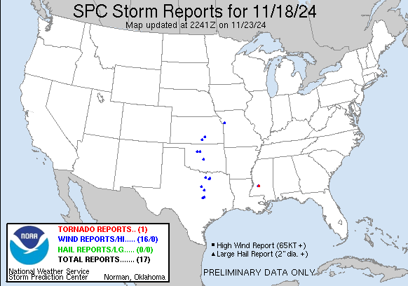
| Tornado Reports (CSV) (Raw Tornado CSV)(?) |
|---|
Time | | Location | County | State | Lat | Lon | Comments |
| 0807 | | 2 WSW Terry | Hinds | MS | 3209 | 9033 | The small short-lived EF-1 tornado developed just south of Tank Road ... quickly moving northeast. The tornado snapped a few trees and a power pole on the south side of (JAN) |
| Hail Reports (CSV) (Raw Hail CSV)(?) |
|---|
| No reports received |
| Wind Reports (CSV) (Raw Wind CSV)(?) |
|---|
Time | Speed | Location | County | State | Lat | Lon | Comments |
| 1200 | UNK | Okeene | Blaine | OK | 3612 | 9832 | Roof blown off of a building. Time is estimated. (OUN) |
| 1216 | 70 | 1 SSW HENNESSEY | KINGFISHER | OK | 3610 | 9790 | BROADCAST MEDIA REPORT OF 70 TO 75 MPH WINDS NEAR HENNESSEY. CORRECTED TIME OF REPORT (OUN) |
| 1255 | 70 | 1 SSW Hennessey | Kingfisher | OK | 3610 | 9790 | Broadcast media report of 70 to 75 mph winds near Hennessey. (OUN) |
| 1310 | UNK | 2 NNE Norman | Cleveland | OK | 3525 | 9743 | Tree uprooted. Social media image. Radar estimated time. (OUN) |
| 1400 | UNK | Glen Rose | Somervell | TX | 3224 | 9774 | Roof off structure and fence damage at Glen Lake Camp in Glen Rose. (FWD) |
| 1405 | UNK | Rainbow | Somervell | TX | 3225 | 9772 | Travel trailers were overturned at RV resort in Rainbow. (FWD) |
| 1445 | UNK | Belton | Bell | TX | 3106 | 9754 | At the Bell County Flea Market in Belton ... a building lost its roof and suffered significant structural damage. (FWD) |
| 1446 | UNK | Whitney | Hill | TX | 3188 | 9734 | Metal building was destroyed on the south side of Lake Whitney. A nearby metal building was also damaged. (FWD) |
| 1458 | UNK | Temple | Bell | TX | 3111 | 9736 | Fire Department reported roof damage and sheet metal removed from buildings in north Temple. In the same area ... public reported damage to a hotel along I-35. (FWD) |
| 1538 | UNK | Allen | Collin | TX | 3309 | 9669 | 8-inch oak tree blown down along Watter Creek in Allen ... near US 75 and Bethany Drive. (FWD) |
| 1548 | 66 | McKinney | Collin | TX | 3318 | 9659 | ASOS at McKinney National Airport recorded a gust to 66 mph. (FWD) |
| 1909 | UNK | 4 NE Krum | Denton | TX | 3330 | 9718 | 18-wheeler blown over on I-35 near Milam Road (FM 3163) ... between Denton and Sanger. (FWD) |
| 2037 | 60 | 2 SE Viola | Sumner | KS | 3746 | 9761 | Measured by the Kansas State Mesonet. (ICT) |
| 2120 | 58 | 3 ESE Bel Aire | Sedgwick | KS | 3775 | 9722 | Gust measured at Jabara Airport. (ICT) |
| 0222 | UNK | 1 S Liberty | Clay | MO | 3924 | 9442 | Report from mPING: 1-inch tree limbs broken; Shingles blown off. (EAX) |
| 0808 | UNK | 2 WSW Terry | Hinds | MS | 3209 | 9034 | Downed powerpole and numerous limbs down along Tank Road. Power outages in the area. Possible tornado. Time estimated based on radar. (JAN) |