|
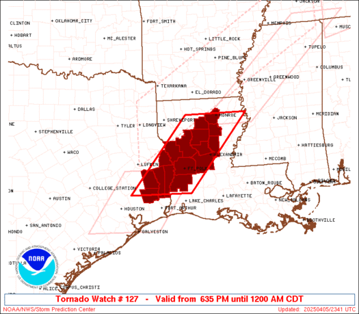
Initial List of Counties in SPC Tornado Watch 127 (WOU)
|
Back to Watch 127
|
 |
   WOUS64 KWNS 052333
   WOU7

   BULLETIN - IMMEDIATE BROADCAST REQUESTED
   TORNADO WATCH OUTLINE UPDATE FOR WT 127
   NWS STORM PREDICTION CENTER NORMAN OK
   635 PM CDT SAT APR 5 2025

   TORNADO WATCH 127 IS IN EFFECT UNTIL 1200 AM CDT FOR THE
    FOLLOWING LOCATIONS

   LAC011-021-043-049-059-069-073-079-085-115-127-060500-
   /O.NEW.KWNS.TO.A.0127.250405T2335Z-250406T0500Z/

   LA
   .    LOUISIANA PARISHES INCLUDED ARE

   BEAUREGARD           CALDWELL            GRANT
   JACKSON              LA SALLE            NATCHITOCHES
   OUACHITA             RAPIDES             SABINE
   VERNON               WINN


   TXC199-241-351-403-457-060500-
   /O.NEW.KWNS.TO.A.0127.250405T2335Z-250406T0500Z/

   TX
   .    TEXAS COUNTIES INCLUDED ARE

   HARDIN               JASPER              NEWTON
   SABINE               TYLER


   ATTN...WFO...LCH...SHV...
|
| Aviation Watch (SAW) for WW127 |
|---|
 |
| Note:
The Aviation Watch (SAW) product is an approximation to the watch area.
The actual watch is depicted by the shaded areas. |
   SAW7
   WW 127 TORNADO LA TX 052335Z - 060500Z
   AXIS..60 STATUTE MILES EAST AND WEST OF LINE..
   5NNW MLU/MONROE LA/ - 70SW POE/FORT POLK LA/
   ..AVIATION COORDS.. 50NM E/W /4NNW MLU - 48WNW LCH/
   HAIL SURFACE AND ALOFT..1.5 INCHES. WIND GUSTS..60 KNOTS.
   MAX TOPS TO 500. MEAN STORM MOTION VECTOR 24035.

   LAT...LON 32589103 30339300 30339502 32589309

   THIS IS AN APPROXIMATION TO THE WATCH AREA.  FOR A
   COMPLETE DEPICTION OF THE WATCH SEE WOUS64 KWNS
   FOR WOU7.
|
|


 @NWSSPC
