|
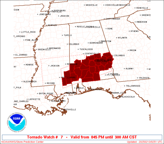
Initial List of Counties in SPC Tornado Watch 7 (WOU)
|
Back to Watch 7
|
 |
   WOUS64 KWNS 130240
   WOU7

   BULLETIN - IMMEDIATE BROADCAST REQUESTED
   TORNADO WATCH OUTLINE UPDATE FOR WT 7
   NWS STORM PREDICTION CENTER NORMAN OK
   845 PM CST WED FEB 12 2025

   TORNADO WATCH 7 IS IN EFFECT UNTIL 300 AM CST FOR THE
    FOLLOWING LOCATIONS

   ALC001-005-011-013-023-025-035-039-041-047-051-053-081-085-087-
   091-099-101-109-113-129-131-130900-
   /O.NEW.KWNS.TO.A.0007.250213T0245Z-250213T0900Z/

   AL
   .    ALABAMA COUNTIES INCLUDED ARE

   AUTAUGA              BARBOUR             BULLOCK
   BUTLER               CHOCTAW             CLARKE
   CONECUH              COVINGTON           CRENSHAW
   DALLAS               ELMORE              ESCAMBIA
   LEE                  LOWNDES             MACON
   MARENGO              MONROE              MONTGOMERY
   PIKE                 RUSSELL             WASHINGTON
   WILCOX


   MSC041-111-153-130900-
   /O.NEW.KWNS.TO.A.0007.250213T0245Z-250213T0900Z/

   MS
   .    MISSISSIPPI COUNTIES INCLUDED ARE

   GREENE               PERRY               WAYNE


   ATTN...WFO...BMX...MOB...
|
| Aviation Watch (SAW) for WW7 |
|---|
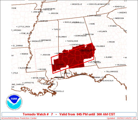 |
| Note:
The Aviation Watch (SAW) product is an approximation to the watch area.
The actual watch is depicted by the shaded areas. |
   SAW7
   WW 7 TORNADO AL MS 130245Z - 130900Z
   AXIS..45 STATUTE MILES NORTH AND SOUTH OF LINE..
   125W GZH/EVERGREEN AL/ - 35SSE AUO/AUBURN AL/
   ..AVIATION COORDS.. 40NM N/S /57E MCB - 55S LGC/
   HAIL SURFACE AND ALOFT..1 INCH. WIND GUSTS..60 KNOTS.
   MAX TOPS TO 500. MEAN STORM MOTION VECTOR 25035.

   LAT...LON 32058916 32798520 31498520 30758916

   THIS IS AN APPROXIMATION TO THE WATCH AREA.  FOR A
   COMPLETE DEPICTION OF THE WATCH SEE WOUS64 KWNS
   FOR WOU7.
|
|


 @NWSSPC
