|
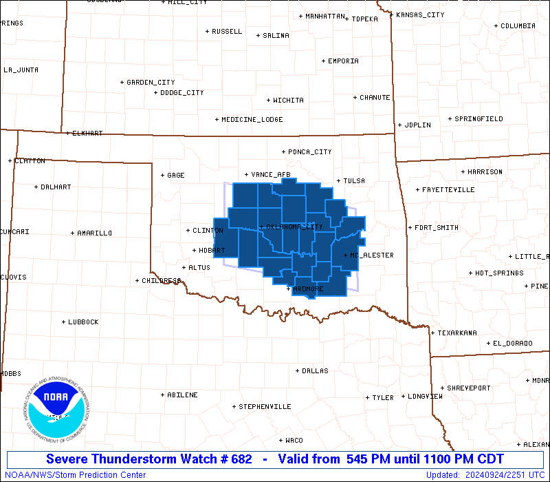
Initial List of Counties in SPC Severe Thunderstorm Watch 682 (WOU)
|
Back to Watch 682
|
 |
   WOUS64 KWNS 242243
   WOU2

   BULLETIN - IMMEDIATE BROADCAST REQUESTED
   SEVERE THUNDERSTORM WATCH OUTLINE UPDATE FOR WS 682
   NWS STORM PREDICTION CENTER NORMAN OK
   545 PM CDT TUE SEP 24 2024

   SEVERE THUNDERSTORM WATCH 682 IS IN EFFECT UNTIL 1100 PM CDT
   FOR THE FOLLOWING LOCATIONS

   OKC005-015-017-027-029-037-049-051-063-069-073-081-083-087-091-
   099-107-109-111-119-121-123-125-133-250400-
   /O.NEW.KWNS.SV.A.0682.240924T2245Z-240925T0400Z/

   OK
   .    OKLAHOMA COUNTIES INCLUDED ARE

   ATOKA                CADDO               CANADIAN
   CLEVELAND            COAL                CREEK
   GARVIN               GRADY               HUGHES
   JOHNSTON             KINGFISHER          LINCOLN
   LOGAN                MCCLAIN             MCINTOSH
   MURRAY               OKFUSKEE            OKLAHOMA
   OKMULGEE             PAYNE               PITTSBURG
   PONTOTOC             POTTAWATOMIE        SEMINOLE


   ATTN...WFO...OUN...TSA...
|
| Aviation Watch (SAW) for WW682 |
|---|
 |
| Note:
The Aviation Watch (SAW) product is an approximation to the watch area.
The actual watch is depicted by the shaded areas. |
   SAW2
   WW 682 SEVERE TSTM OK 242245Z - 250400Z
   AXIS..50 STATUTE MILES NORTH AND SOUTH OF LINE..
   35NW CHK/CHICKASHA OK/ - 15ENE MLC/MCALESTER OK/
   ..AVIATION COORDS.. 45NM N/S /40W OKC - 14ENE MLC/
   HAIL SURFACE AND ALOFT..2 INCHES. WIND GUSTS..60 KNOTS.
   MAX TOPS TO 500. MEAN STORM MOTION VECTOR 28030.

   LAT...LON 36189841 35689554 34249554 34739841

   THIS IS AN APPROXIMATION TO THE WATCH AREA.  FOR A
   COMPLETE DEPICTION OF THE WATCH SEE WOUS64 KWNS
   FOR WOU2.
|
|


 @NWSSPC