|
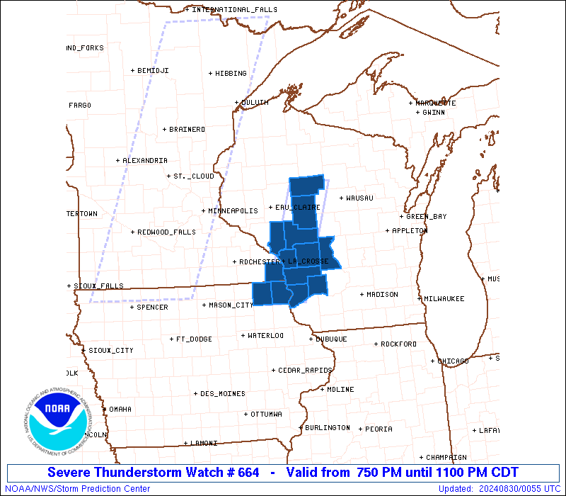
Initial List of Counties in SPC Severe Thunderstorm Watch 664 (WOU)
|
Back to Watch 664
|
 |
   WOUS64 KWNS 300045
   WOU4

   BULLETIN - IMMEDIATE BROADCAST REQUESTED
   SEVERE THUNDERSTORM WATCH OUTLINE UPDATE FOR WS 664
   NWS STORM PREDICTION CENTER NORMAN OK
   750 PM CDT THU AUG 29 2024

   SEVERE THUNDERSTORM WATCH 664 IS IN EFFECT UNTIL 1100 PM CDT
   FOR THE FOLLOWING LOCATIONS

   IAC005-191-300400-
   /O.NEW.KWNS.SV.A.0664.240830T0050Z-240830T0400Z/

   IA
   .    IOWA COUNTIES INCLUDED ARE

   ALLAMAKEE            WINNESHIEK


   MNC055-300400-
   /O.NEW.KWNS.SV.A.0664.240830T0050Z-240830T0400Z/

   MN
   .    MINNESOTA COUNTIES INCLUDED ARE

   HOUSTON


   WIC019-023-053-057-063-081-103-119-121-123-300400-
   /O.NEW.KWNS.SV.A.0664.240830T0050Z-240830T0400Z/

   WI
   .    WISCONSIN COUNTIES INCLUDED ARE

   CLARK                CRAWFORD            JACKSON
   JUNEAU               LA CROSSE           MONROE
   RICHLAND             TAYLOR              TREMPEALEAU
   VERNON


   ATTN...WFO...ARX...
|
| Aviation Watch (SAW) for WW664 |
|---|
 |
| Note:
The Aviation Watch (SAW) product is an approximation to the watch area.
The actual watch is depicted by the shaded areas. |
   SAW4
   WW 664 SEVERE TSTM IA MN WI 300050Z - 300400Z
   AXIS..25 STATUTE MILES EAST AND WEST OF LINE..
   105NNE LSE/LA CROSSE WI/ - 55S LSE/LA CROSSE WI/
   ..AVIATION COORDS.. 20NM E/W /46WSW RHI - 47NNW DBQ/
   HAIL SURFACE AND ALOFT..1 INCH. WIND GUSTS..60 KNOTS.
   MAX TOPS TO 500. MEAN STORM MOTION VECTOR 26030.

   LAT...LON 45288991 43089075 43089175 45289094

   THIS IS AN APPROXIMATION TO THE WATCH AREA.  FOR A
   COMPLETE DEPICTION OF THE WATCH SEE WOUS64 KWNS
   FOR WOU4.
|
|


 @NWSSPC