|
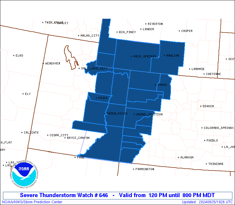
Initial List of Counties in SPC Severe Thunderstorm Watch 646 (WOU)
|
Back to Watch 646
|
 |
   WOUS64 KWNS 251919
   WOU6

   BULLETIN - IMMEDIATE BROADCAST REQUESTED
   SEVERE THUNDERSTORM WATCH OUTLINE UPDATE FOR WS 646
   NWS STORM PREDICTION CENTER NORMAN OK
   120 PM MDT SUN AUG 25 2024

   SEVERE THUNDERSTORM WATCH 646 IS IN EFFECT UNTIL 800 PM MDT
   FOR THE FOLLOWING LOCATIONS

   COC029-033-045-077-081-083-085-103-107-113-260200-
   /O.NEW.KWNS.SV.A.0646.240825T1920Z-240826T0200Z/

   CO
   .    COLORADO COUNTIES INCLUDED ARE

   DELTA                DOLORES             GARFIELD
   MESA                 MOFFAT              MONTEZUMA
   MONTROSE             RIO BLANCO          ROUTT
   SAN MIGUEL


   UTC007-009-013-015-019-037-043-047-055-260200-
   /O.NEW.KWNS.SV.A.0646.240825T1920Z-240826T0200Z/

   UT
   .    UTAH COUNTIES INCLUDED ARE

   CARBON               DAGGETT             DUCHESNE
   EMERY                GRAND               SAN JUAN
   SUMMIT               UINTAH              WAYNE


   WYC007-023-037-041-260200-
   /O.NEW.KWNS.SV.A.0646.240825T1920Z-240826T0200Z/

   WY
   .    WYOMING COUNTIES INCLUDED ARE

   CARBON               LINCOLN             SWEETWATER
   UINTA


   ATTN...WFO...GJT...SLC...RIW...CYS...
|
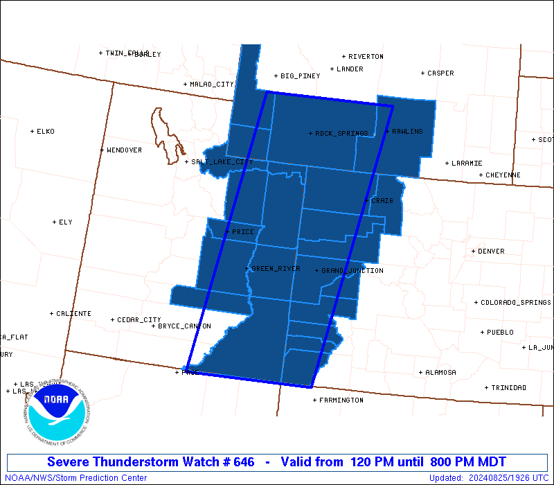
| Aviation Watch (SAW) for WW646 |
|---|
 |
| Note:
The Aviation Watch (SAW) product is an approximation to the watch area.
The actual watch is depicted by the shaded areas. |
   SAW6
   WW 646 SEVERE TSTM CO UT WY 251920Z - 260200Z
   AXIS..80 STATUTE MILES EAST AND WEST OF LINE..
   50NNE RKS/ROCK SPRINGS WY/ - 45SSW 4BL/BLANDING UT/
   ..AVIATION COORDS.. 70NM E/W /43NNE OCS - 65SW DVC/
   HAIL SURFACE AND ALOFT..2 INCHES. WIND GUSTS..60 KNOTS.
   MAX TOPS TO 450. MEAN STORM MOTION VECTOR 23030.

   LAT...LON 42260713 36970834 36971124 42261026

   THIS IS AN APPROXIMATION TO THE WATCH AREA.  FOR A
   COMPLETE DEPICTION OF THE WATCH SEE WOUS64 KWNS
   FOR WOU6.
|
|


 @NWSSPC