|
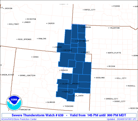
Initial List of Counties in SPC Severe Thunderstorm Watch 639 (WOU)
|
Back to Watch 639
|
 |
   WOUS64 KWNS 191942
   WOU9

   BULLETIN - IMMEDIATE BROADCAST REQUESTED
   SEVERE THUNDERSTORM WATCH OUTLINE UPDATE FOR WS 639
   NWS STORM PREDICTION CENTER NORMAN OK
   145 PM MDT MON AUG 19 2024

   SEVERE THUNDERSTORM WATCH 639 IS IN EFFECT UNTIL 900 PM MDT
   FOR THE FOLLOWING LOCATIONS

   COC017-025-039-041-061-063-073-075-087-089-101-121-123-125-
   200300-
   /O.NEW.KWNS.SV.A.0639.240819T1945Z-240820T0300Z/

   CO
   .    COLORADO COUNTIES INCLUDED ARE

   CHEYENNE             CROWLEY             ELBERT
   EL PASO              KIOWA               KIT CARSON
   LINCOLN              LOGAN               MORGAN
   OTERO                PUEBLO              WASHINGTON
   WELD                 YUMA


   NEC007-013-033-045-105-123-157-165-200300-
   /O.NEW.KWNS.SV.A.0639.240819T1945Z-240820T0300Z/

   NE
   .    NEBRASKA COUNTIES INCLUDED ARE

   BANNER               BOX BUTTE           CHEYENNE
   DAWES                KIMBALL             MORRILL
   SCOTTS BLUFF         SIOUX


   WYC015-021-200300-
   /O.NEW.KWNS.SV.A.0639.240819T1945Z-240820T0300Z/

   WY
   .    WYOMING COUNTIES INCLUDED ARE

   GOSHEN               LARAMIE


   ATTN...WFO...GLD...CYS...BOU...PUB...
|
| Aviation Watch (SAW) for WW639 |
|---|
 |
| Note:
The Aviation Watch (SAW) product is an approximation to the watch area.
The actual watch is depicted by the shaded areas. |
   SAW9
   WW 639 SEVERE TSTM CO NE WY 191945Z - 200300Z
   AXIS..35 STATUTE MILES EAST AND WEST OF LINE..
   25SE PUB/PUEBLO CO/ - 20NW CDR/CHADRON NE/
   ..AVIATION COORDS.. 30NM E/W /20SE PUB - 59SSW RAP/
   HAIL SURFACE AND ALOFT..2 INCHES. WIND GUSTS..60 KNOTS.
   MAX TOPS TO 500. MEAN STORM MOTION VECTOR 24025.

   LAT...LON 38020482 43030407 43030269 38020353

   THIS IS AN APPROXIMATION TO THE WATCH AREA.  FOR A
   COMPLETE DEPICTION OF THE WATCH SEE WOUS64 KWNS
   FOR WOU9.
|
|


 @NWSSPC
