|
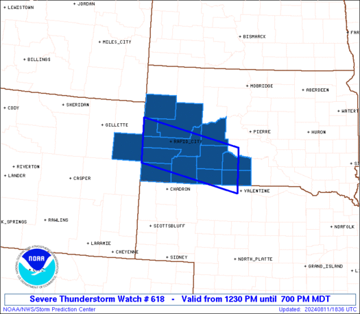
Initial List of Counties in SPC Severe Thunderstorm Watch 618 (WOU)
|
Back to Watch 618
|
 |
   WOUS64 KWNS 111827
   WOU8

   BULLETIN - IMMEDIATE BROADCAST REQUESTED
   SEVERE THUNDERSTORM WATCH OUTLINE UPDATE FOR WS 618
   NWS STORM PREDICTION CENTER NORMAN OK
   1230 PM MDT SUN AUG 11 2024

   SEVERE THUNDERSTORM WATCH 618 IS IN EFFECT UNTIL 700 PM MDT
   FOR THE FOLLOWING LOCATIONS

   SDC007-019-033-047-055-071-081-093-095-102-103-121-120100-
   /O.NEW.KWNS.SV.A.0618.240811T1830Z-240812T0100Z/

   SD
   .    SOUTH DAKOTA COUNTIES INCLUDED ARE

   BENNETT              BUTTE               CUSTER
   FALL RIVER           HAAKON              JACKSON
   LAWRENCE             MEADE               MELLETTE
   OGLALA LAKOTA        PENNINGTON          TODD


   WYC045-120100-
   /O.NEW.KWNS.SV.A.0618.240811T1830Z-240812T0100Z/

   WY
   .    WYOMING COUNTIES INCLUDED ARE

   WESTON


   ATTN...WFO...UNR...
|
| Aviation Watch (SAW) for WW618 |
|---|
 |
| Note:
The Aviation Watch (SAW) product is an approximation to the watch area.
The actual watch is depicted by the shaded areas. |
   SAW8
   WW 618 SEVERE TSTM SD WY 111830Z - 120100Z
   AXIS..40 STATUTE MILES NORTH AND SOUTH OF LINE..
   50W RAP/RAPID CITY SD/ - 65SE PHP/PHILIP SD/
   ..AVIATION COORDS.. 35NM N/S /45W RAP - 57NNW ANW/
   HAIL SURFACE AND ALOFT..2 INCHES. WIND GUSTS..60 KNOTS.
   MAX TOPS TO 500. MEAN STORM MOTION VECTOR 28030.

   LAT...LON 44620406 43960068 42800068 43470406

   THIS IS AN APPROXIMATION TO THE WATCH AREA.  FOR A
   COMPLETE DEPICTION OF THE WATCH SEE WOUS64 KWNS
   FOR WOU8.
|
|


