|
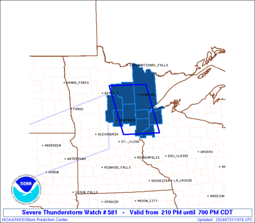
Initial List of Counties in SPC Severe Thunderstorm Watch 581 (WOU)
|
Back to Watch 581
|
 |
   WOUS64 KWNS 311908
   WOU1

   BULLETIN - IMMEDIATE BROADCAST REQUESTED
   SEVERE THUNDERSTORM WATCH OUTLINE UPDATE FOR WS 581
   NWS STORM PREDICTION CENTER NORMAN OK
   210 PM CDT WED JUL 31 2024

   SEVERE THUNDERSTORM WATCH 581 IS IN EFFECT UNTIL 700 PM CDT
   FOR THE FOLLOWING LOCATIONS

   MNC001-017-021-035-061-115-137-010000-
   /O.NEW.KWNS.SV.A.0581.240731T1910Z-240801T0000Z/

   MN
   .    MINNESOTA COUNTIES INCLUDED ARE

   AITKIN               CARLTON             CASS
   CROW WING            ITASCA              PINE
   ST. LOUIS


   WIC013-031-010000-
   /O.NEW.KWNS.SV.A.0581.240731T1910Z-240801T0000Z/

   WI
   .    WISCONSIN COUNTIES INCLUDED ARE

   BURNETT              DOUGLAS


   LSZ145-010000-
   /O.NEW.KWNS.SV.A.0581.240731T1910Z-240801T0000Z/

   CW

   .    ADJACENT COASTAL WATERS INCLUDED ARE

   DULUTH MN TO PORT WING WI

   ATTN...WFO...DLH...
|
| Aviation Watch (SAW) for WW581 |
|---|
 |
| Note:
The Aviation Watch (SAW) product is an approximation to the watch area.
The actual watch is depicted by the shaded areas. |
   SAW1
   WW 581 SEVERE TSTM MN WI LS 311910Z - 010000Z
   AXIS..50 STATUTE MILES EAST AND WEST OF LINE..
   40NW HIB/HIBBING MN/ - 75SSW DLH/DULUTH MN/
   ..AVIATION COORDS.. 45NM E/W /47S INL - 60NNE MSP/
   HAIL SURFACE AND ALOFT..1.5 INCHES. WIND GUSTS..65 KNOTS.
   MAX TOPS TO 500. MEAN STORM MOTION VECTOR 26040.

   LAT...LON 47789236 45829174 45829381 47789452

   THIS IS AN APPROXIMATION TO THE WATCH AREA.  FOR A
   COMPLETE DEPICTION OF THE WATCH SEE WOUS64 KWNS
   FOR WOU1.
|
|


