|
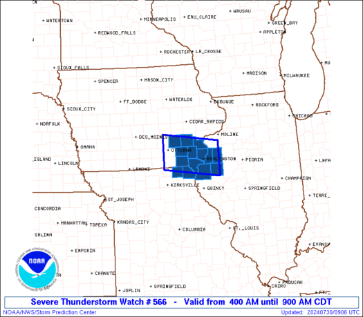
Initial List of Counties in SPC Severe Thunderstorm Watch 566 (WOU)
|
Back to Watch 566
|
 |
   WOUS64 KWNS 300856
   WOU6

   BULLETIN - IMMEDIATE BROADCAST REQUESTED
   SEVERE THUNDERSTORM WATCH OUTLINE UPDATE FOR WS 566
   NWS STORM PREDICTION CENTER NORMAN OK
   400 AM CDT TUE JUL 30 2024

   SEVERE THUNDERSTORM WATCH 566 IS IN EFFECT UNTIL 900 AM CDT
   FOR THE FOLLOWING LOCATIONS

   IAC057-087-101-107-111-115-177-183-301400-
   /O.NEW.KWNS.SV.A.0566.240730T0900Z-240730T1400Z/

   IA
   .    IOWA COUNTIES INCLUDED ARE

   DES MOINES           HENRY               JEFFERSON
   KEOKUK               LEE                 LOUISA
   VAN BUREN            WASHINGTON


   ILC067-071-109-187-301400-
   /O.NEW.KWNS.SV.A.0566.240730T0900Z-240730T1400Z/

   IL
   .    ILLINOIS COUNTIES INCLUDED ARE

   HANCOCK              HENDERSON           MCDONOUGH
   WARREN


   MOC045-199-301400-
   /O.NEW.KWNS.SV.A.0566.240730T0900Z-240730T1400Z/

   MO
   .    MISSOURI COUNTIES INCLUDED ARE

   CLARK                SCOTLAND


   ATTN...WFO...DVN...
|
| Aviation Watch (SAW) for WW566 |
|---|
 |
| Note:
The Aviation Watch (SAW) product is an approximation to the watch area.
The actual watch is depicted by the shaded areas. |
   SAW6
   WW 566 SEVERE TSTM IA IL MO 300900Z - 301400Z
   AXIS..35 STATUTE MILES NORTH AND SOUTH OF LINE..
   10WSW OTM/OTTUMWA IA/ - 30E BRL/BURLINGTON IA/
   ..AVIATION COORDS.. 30NM N/S /52ESE DSM - 49WSW BDF/
   HAIL SURFACE AND ALOFT..1 INCH. WIND GUSTS..65 KNOTS.
   MAX TOPS TO 500. MEAN STORM MOTION VECTOR 30040.

   LAT...LON 41559263 41299056 40279056 40549263

   THIS IS AN APPROXIMATION TO THE WATCH AREA.  FOR A
   COMPLETE DEPICTION OF THE WATCH SEE WOUS64 KWNS
   FOR WOU6.
|
|


